
Weekly Surf Forecast: August 30 - September 5, 2026
Updated Wednesday, September 2. The week changed shape mid-stream — read the mid-week update first, then the original Sunday forecast below, which we have left exactly as written.
Here's the week ahead — August 30 to September 5, 2026 — built from our 50-meter nearshore SWAN model, the grid that resolves what a swell actually does in the last mile, after it leaves the buoy and starts feeling the bottom.
The honest read: this is a quiet week for most of the map. One region has genuine surf — Southern California, on a long-period SSW groundswell that builds toward the weekend. Everywhere else is short-period windswell with a narrow dawn window and an afternoon that falls apart, and Puerto Rico is essentially off. If you only take one line from this: surf early, and set your expectations by region rather than by the calendar.
Mid-week update — Wednesday, September 2
The short version: the Southern Hemisphere swell we built Sunday's post around came in on schedule and has already faded. What replaces it is bigger, later and from a different source: Tropical Storm Marie, which formed south of the tip of Baja out of the East Pacific wave we told you to watch "for the week after this one." It arrives Friday evening. Southern California's weekend is now the biggest surf on the map, the peak has slid from Saturday into Sunday, and the East Coast is still running on the same short-period windswell we described, with a couple of the windows moving.
What the buoys said about Sunday's call
We called a long-period SSW groundswell of Southern Hemisphere origin. The Oceanside Offshore buoy — the closest open-water reading to Trestles — recorded 4.3 ft of swell at 16.7 seconds from the SSW on Sunday, and Santa Monica Basin read 4.6 ft at 14.8 seconds from the same direction. That is the swell we described, at the size we described, from the direction we described. What we got wrong was the shape of the week. We wrote that it would "build toward the weekend." It did not: it peaked Sunday and Monday and has faded steadily since, down to 2 ft of swell at Oceanside by this morning. On Monday and Tuesday the buoys also show the direction veering to south-southeast at 11-13 seconds on top of the fading SSW — that is Hurricane Karina's contribution, exactly the "bonus" we said it would be. The miss is that the model's Saturday peak, six days out, was a different swell entirely, and we described it as if it were the same one.
The Atlantic held the script. The Gulf low we called "a rain story for the central Gulf coast" went into Texas as Tropical Depression Edouard, and the National Hurricane Center's Wednesday outlook expects no Atlantic development for the next seven days. The Diamond Shoals buoy has not reported a spectral swell partition all week, so our Wednesday-dawn Hatteras call goes unverified. We'd rather say that than claim it.
Southern California: Marie takes over the weekend

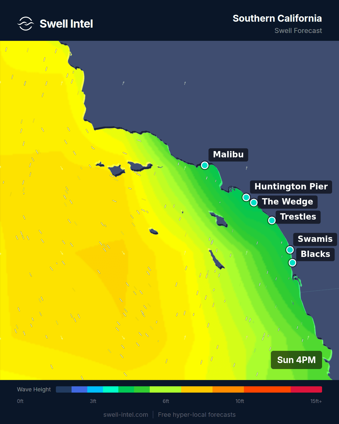
Here is what the model has in the water now, spot by spot, quoting the max breaking number for each local day. Trestles is 4 ft this morning on the last of the SSW at 10.6 seconds, drops to 3+ ft and Poor-Fair on Thursday in the lull, then the new swell shows Friday evening: 5 ft at 8 pm on 14.1 seconds from 166°, south-southeast. Saturday is 7 ft, peaking late afternoon at 13.9 seconds from 175°, rated Good from morning through evening. Sunday is the peak: 9 ft at midday on 13.3 seconds from 184°, Good all day. Monday holds 7 ft at dawn on 11.9 seconds.
Malibu First Point takes the same energy a size smaller and a step earlier: 6 ft Saturday, peaking at 8 am on 14.9 seconds from 168°, Good through midday; 6 ft again Sunday and Monday at 13.7 and 12.4 seconds, Good from first light to dark. The direction is the tell. It walks from 166° on Friday to 175° Saturday to 184° Sunday as Marie tracks west-northwest away from the Baja tip, and a 13-14 second period at that range is a tropical signature, not a Southern Hemisphere one. Sunday's post said a tropical contribution would be a bonus. For this weekend it is the whole event.
Two things are still moving. The direction matters more than the size: at 166-175° on Saturday, Trestles and the south-facing San Diego reefs are square to it while Malibu gets it through a narrower gap; by 184° on Sunday everything from Ventura to San Diego is in play. The wind is the ordinary late-summer question, and the model answers it the same way it did on Sunday: mornings are cleanest, and both Saturday and Sunday hold a Good rating past midday. Thursday is the day to skip.
Everywhere else, in the order that matters
- Northern California. We said the long-period south energy would mostly fail to turn the corner into Ocean Beach. That was too strong: the model now has 16-18 second SSW energy as OB's primary band Friday and Saturday. It is small — around 2 ft of swell — so it makes OB 4 ft and Fair-Good at dawn Saturday rather than big, but it is there and we should have said so. Saturday morning stays the call, and the afternoons are still no good.
- Pacific Northwest. Thursday is bigger than we called and worse. The wind has swung south ahead of a front, so Indian Beach shows 9 ft at 9 am on 10.8 seconds from 281° but rates only Poor-Fair to Fair. Friday morning is the cleaner session: 5 ft at dawn on 9.5 seconds, Fair-Good. Take the smaller day.
- New York / New Jersey. The window moved up. Manasquan is 3 ft Thursday afternoon on 6.2 seconds from 106°, Fair-Good, and that is the best of the week; Friday drops to 2 ft and Poor-Fair, and Saturday is Poor. Go Thursday after work, not Friday.
- Outer Banks. Thursday dawn is the last window this week: 3 ft at Cape Hatteras on 8.9 seconds from 128°, Fair-Good in the morning and Poor-Fair by afternoon. Friday and Saturday are Poor. A northeast wind event Sunday and Monday blows it out entirely, then cleans up into the following Wednesday, September 9, when Hatteras shows 4 ft on 7.7 seconds from 66° with a Good morning rating. Worth watching; we'll update as it gets closer.
- Florida East Coast. Monday's window came and went. What is left is Friday morning: Cocoa Beach 3+ ft at dawn on 6.3 seconds from 102°, Fair through midday and Poor by afternoon. Saturday through Monday are Poor across the Space Coast.
- New England. The Friday midday window we called has slipped to Poor-Fair at 2 ft. The model's first real window is now Sunday, September 6: Hampton Beach 3 ft at dawn on 6.9 seconds from 65°, Fair-Good all day, on the back of that same northeast wind. Rhode Island is still off.
- Puerto Rico. Still off through the weekend. A small east-northeast bump shows Tuesday, September 8 — Maria's up to 3 ft and Fair on the model's best hour — but it is not a reason to change plans.
The original Sunday forecast follows, unedited.
Why the map looks like this
The setup is worth understanding, because it is unusual for the date. We are eleven days out from the climatological peak of Atlantic hurricane season, and the Atlantic is blank. As of Sunday morning's outlook the National Hurricane Center has no named storms in the basin — only the sheared-out remnants of Dolly drifting past Puerto Rico and the northern Leewards with no closed surface circulation and near 0% development odds over 48 hours, plus a low in the northern Gulf about 125 miles south of southeastern Louisiana at 30%. That Gulf feature is a rain story for the central Gulf coast, not a swell producer for anybody reading this.
With no Atlantic tropical system spinning up wave energy, the entire Eastern Seaboard is running on trade-wind and local windswell — which is exactly what our model shows: primary periods of 3 to 8.6 seconds from Florida to Maine. Period is the tell. Groundswell that has traveled from a distant storm arrives long and organized; sea generated by nearby wind arrives short and disorganized. This week the East Coast is almost entirely the second thing.
The activity went to the East Pacific instead. Hurricane Karina is west-southwest of the southern tip of Baja, Tropical Storm Lowell sits east-southeast of Hawaii, and the NHC has a wave well offshore of southwestern Mexico at 60% development odds over 48 hours and 90% over seven days. That last one is the system worth watching for the week after this one. It is not what is lighting up Southern California right now — more on that below.
Jump to your coast
- Mid-week update (Wed Sep 2) — Marie takes over the SoCal weekend; buoy receipts on Sunday's call
- Southern California — 2-4ft, the only real swell on the map
- Northern California — 2-3ft, dawn or nothing
- Pacific Northwest — 2-3ft, big numbers on short period
- New York / New Jersey — 1-2ft, modest ESE windswell
- New England — 1-2ft, the weakest week on the coast
- Outer Banks — 1-2ft, the East Coast's best session
- Florida East Coast — 1-2ft, tomorrow morning is the window
- Puerto Rico — 0-1ft, it's off
Southern California

Surf: 2-4ft • Best day: Saturday (Sep 5) AM • Conditions: Good
This is the one region with a real swell in it. The model has a long-period south-southwest band filling in across the week: 15.3 seconds from 196° at Trestles, 15.4 seconds from 202° at Malibu, the same 15-second energy at Cardiff. That combination — very long period arriving from just west of due south — is a Southern Hemisphere signature. It is a distant storm, not the local tropics. Karina sits further east in the swell window on a much shorter fetch, so treat any tropical contribution as a bonus rather than the main event. The practical consequence of a 15-second band at 196-202° is that it has the wavelength to refract around Catalina and the Channel Islands and still arrive with power at the south-facing beaches.
Trestles is the standout, rating Good, with our model topping out around 9ft on the biggest sets of the peak pulse — but calibrate that against the regional typical range of 2-4ft. Plan for waist- to head-high through most of the week and treat the overhead sets as the model's ceiling on the best hour, not as a promise. Malibu's First Point is up to 7ft on the same 15.4-second energy from 202°, and that cobble point is angled almost perfectly to take it. Cardiff Reef is up to 4ft and Good. Huntington Pier reaches 6ft but its dominant band there is a 6.4-second west windswell at 271°, so expect a mushier, less organized wave than the numbers suggest. El Porto is the honest exception: 2ft and Poor-Fair. El Porto faces west-northwest, and a 200° swell walks straight past it — Santa Monica Bay's south window is narrow and Palos Verdes blocks the rest. If you are in the South Bay this week, drive south.
Best bets: Trestles or Malibu First Point, Saturday morning. The AM window rates clearly ahead of midday and well ahead of the afternoon — standard late-summer sea breeze, so be out of the water by mid-morning. Confidence: high on the swell arriving and on the SSW direction; moderate on the top end, because Saturday is six days out and a peak-set number is the least reliable figure in any forecast.
Northern California

Surf: 2-3ft • Best day: Saturday (Sep 5) AM • Conditions: Fair
Northern California does not share in SoCal's swell, and it is worth understanding why: that 15-second energy is arriving from 196°, and Ocean Beach and Linda Mar face west to northwest. A swell from just west of due south reaches them at a glancing angle, and most of it simply never turns the corner. What NorCal has instead is locally generated northwest windswell — Ocean Beach on 7.0 seconds from 278°, Linda Mar on 7.3 seconds from 295°. Seven seconds is not groundswell. That is the North Pacific thermal-trough gradient piling up short-period sea a few hundred miles offshore, and it breaks like it.
So be realistic about the ceiling. Ocean Beach is the biggest thing in the region at up to 4ft and rates Fair — that is the best it gets all week. Linda Mar tops out at 2ft and rates Poor-Fair, which makes it a longboard session rather than a search. Typical surf across the region is 2-3ft. This is not a week to drive for.
Best bets: Ocean Beach at dawn, and genuinely only at dawn. The daily shape here is the sharpest on the entire map — the morning window is the only one that rates at all, midday drops to Poor, and by afternoon our model puts the region below Poor as the northwest onshore fills in. Saturday is nominally the best day, but the morning-versus-afternoon split matters far more than which day you pick. If you are not in the water by eight, skip it. Confidence: high on the pattern, which is textbook late-summer NorCal; low on any single day standing out from the rest.
Pacific Northwest

Surf: 2-3ft • Best day: Thursday (Sep 3) AM • Conditions: Good
The Pacific Northwest carries the biggest raw numbers outside of SoCal's peak — Cape Kiwanda to 8ft, Indian Beach to 7ft, Seaside Cove and La Push both to 5ft — but read the period before you get excited. All of it is running on 7.3 to 7.7 seconds from 290-304°, west-northwest to northwest. That is windswell. Eight feet at 7.7 seconds is a short, steep, fast-closing wall, not a long-period peak that stands up and waits for you. The Oregon and Washington coast faces west-northwest and is exposed to everything, which is why the heights look impressive; the ratings are the more useful number here, and they land at Fair-Good to Good rather than higher.
Wind decides the rest, as it always does up here. Thursday morning is the clear standout — our model rates the AM window well ahead of anything else in the region this week — before it collapses through midday as the onshore northwest fills in, with a partial recovery late in the day. Indian Beach and Seaside Cove hold the best ratings at Good; Cape Kiwanda is the biggest at 8ft but only rates Fair-Good, which in a short-period regime usually means it is oversized for the period and breaking too fast to make. La Push is Fair-Good at up to 5ft.
Best bets: Seaside Cove or Indian Beach at first light Thursday, with Cape Kiwanda for whoever wants the size and can handle the speed. Confidence: moderate. Thursday is four days out, and in a windswell regime the wave forecast is only ever as good as the wind forecast underneath it — check again Tuesday.
New York / New Jersey

Surf: 1-2ft • Best day: Friday (Sep 4) PM • Conditions: Fair-Good
Small week, and there is no way to dress that up. Typical surf across the region is 1-2ft. The model does find a modest east-southeast windswell — 7.6 to 7.7 seconds from 108-125° — which is a respectable period for the Mid-Atlantic in a dead tropical pattern, but there is no groundswell behind it and nothing in the basin capable of making one before next weekend.
The angle sorts the coast, and this is where the fine grid earns its keep. Manasquan tops out at 3ft and rates Fair-Good on 7.6 seconds from 108°, and Pacific Blvd matches it at up to 3ft on 7.7 seconds from 124°. The New Jersey beaches face east-southeast, so this swell arrives close to square-on and the sandbars get a clean shot at it. Rockaway gets the same 7.7 seconds from 125° and manages only 2ft at Poor-Fair — the Rockaway peninsula is angled well south of the swell direction, so that energy arrives off-axis and refracts down before it ever reaches the bars. Same swell, different geometry, a full rating band apart. If you have the choice, go to Jersey.
Best bets: Manasquan or Pacific Blvd, Friday. Unusually, this is not a dawn-patrol region this week — our model rates the morning, midday and afternoon windows within a hair of each other with a slight edge to the afternoon, so the sea-breeze penalty is mild and you can sleep in. Confidence: low to moderate. Friday is five days out, this is windswell rather than groundswell, and windswell at that range moves. Check it again midweek.
New England

Surf: 1-2ft • Best day: Friday (Sep 4) Midday • Conditions: Fair-Good
This is the weakest week anywhere on the East Coast, and that Fair-Good label is doing a lot of work — it describes the single best hour anywhere in the region across seven days. Averaged across the daylight hours, our model has New England sitting between Poor and Poor-Fair from dawn to dark, every day of the week. Typical surf is 1-2ft. Set expectations accordingly, or use the week for something else.
The region splits cleanly, and the split is instructive. Hampton Beach in New Hampshire and Nantasket in Massachusetts face east to northeast and pick up a weak 6.1-second windswell from 91-103°, roughly due east. Hampton is the pick of the region at up to 3ft and Fair-Good; Nantasket is up to 3ft and Fair. Marginal, but real. Rhode Island has nothing. Narragansett and Misquamicut face south to southeast, and what the model puts on them is 3.2 to 3.4 seconds from 214-241° — southwest to west-southwest. A three-second period is not swell; it is local wind ripple, and from that direction it is blowing across and off the beach rather than into it. Narragansett tops at 2ft, Misquamicut at 3ft, and both rate Poor-Fair. It is a longboard-or-skip week in Rhode Island, and mostly a skip.
Best bets: Hampton Beach, Friday around midday, which is the only window our model gives the region that is worth the drive. Confidence: low — Friday is five days out and the whole signal is small enough that a modest shift in wind direction changes the answer entirely.
Outer Banks

Surf: 1-2ft • Best day: Wednesday (Sep 2) AM • Conditions: Good
The best-quality call on the East Coast this week, though "best" is relative when the Atlantic is empty. Cape Hatteras is running 8.6 seconds from 123°, east-southeast — the longest primary period anywhere on the Eastern Seaboard on this forecast — and rates Good at up to 3ft. That is Hatteras doing exactly what it is famous for: it juts far enough into the Atlantic to intercept energy that never reaches the rest of the coast, and at 8.6 seconds the swell has enough organization to stand up properly on the outer bars instead of crumbling on the way in.
Folly Beach Pier in South Carolina also reaches 3ft, but on 4.3 seconds from 128° — half the period, and it shows in the rating at Fair-Good. That is short-period sea wrapping in, not the same swell that Hatteras is getting. Note too that regional typical surf is 1-2ft, so do not read the 3ft peak as a week-long number; it is the top of one pulse.
Best bets: Cape Hatteras at dawn Wednesday, and it is not close. The morning window rates well ahead of midday, and the afternoon falls to Poor as the sea breeze fills in. On this forecast that session is the single best hour of surf available anywhere on the East Coast. Confidence: moderate to high on the timing — Wednesday is only three days out and the clean-morning, blown-afternoon pattern is stable this time of year — and moderate on size.
Florida East Coast

Surf: 1-2ft • Best day: Monday (Aug 31) AM • Conditions: Good
Florida gets the earliest window on this forecast — tomorrow morning. Cocoa Beach is the standout at up to 4ft and Good, the largest single spot number on the East Coast this week, running on 5.4 seconds from 87°, essentially due east. Sebastian Inlet is up to 3ft and Fair-Good on 5.0 seconds from 79°, and Jacksonville Beach is up to 3ft and Fair on 4.7 seconds from 107°.
Be clear about what that is, though. Five seconds is trade-wind sea, not swell — short, fast, weak in the shoulder, and entirely at the mercy of the local wind. Typical regional surf is 1-2ft, and the 4ft at Cocoa is the crest of a wind-driven pulse rather than anything organized. Sebastian Inlet, normally the quality play on this stretch when there is real swell to work with, rates below Cocoa here precisely because there is not any. It will be fun on a small board at first light. It will not be memorable.
Best bets: Cocoa Beach tomorrow morning, early. Our model rates the Monday AM window strongly and then drops Florida to near-Poor by the afternoon — that is the Atlantic sea breeze doing what it does to the Space Coast every summer afternoon. Be out by nine. Confidence: high, because this is a one-day-out call in a pattern that is already in place.
Puerto Rico

Surf: 0-1ft • Best day: Monday (Aug 31) Midday • Conditions: Fair
This one is easy to write: it is not happening. Our model has Puerto Rico at 0-1ft typical for the week, with average conditions sitting between Very Poor and Poor at every hour of every day. That is less a bad forecast than the wrong month — the north-coast season runs on north to northwest groundswell from October through April, and late August is the bottom of the annual cycle.
What little energy there is arrives from the northeast, 7.4 seconds from 49-54°. That is trade swell wrapping onto the coast rather than groundswell aimed at it. Wilderness, up near Aguadilla, faces north-northwest and is the only spot catching any of it — up to 3ft and Fair at the peak. Maria's in Rincón faces west-northwest and is almost completely shadowed from a northeast angle, topping out at 2ft and rating Poor. The usual rule here is that the north coast runs bigger and Rincón runs cleaner a couple of feet smaller; this week neither half of that trade-off is worth acting on.
Best bets: none, honestly. Add the weather on top: the remnants of Dolly are tracking through the northern Leewards, the Virgin Islands and Puerto Rico over the next few days. With no closed circulation and near-zero development odds over 48 hours it is not going to make swell, but it will mean showers, gusty easterlies and a messy sea state layered over an already tiny forecast. This is a snorkel week. Come back in October, when the north swell window opens.
Track it live in Swell Intel
Every number above comes from the same 50-meter nearshore SWAN model that runs continuously inside Swell Intel — spot by spot, hour by hour, for all eight regions in this post. A weekly forecast is a snapshot; the two calls most likely to move between now and Saturday are the top end of that Southern Hemisphere pulse into Trestles and Malibu, and whether the East Pacific system off southwestern Mexico develops into something that matters for Southern California the week after. Watch both live at swell-intel.com rather than waiting for next Sunday.
📱 Get spot-by-spot forecasts, dawn patrol alerts, and buoy-trained ratings in the SwellIntel app.