
Weekly Surf Forecast: August 16-22, 2026
Every number below comes out of our nearshore SWAN model, run down to a 50-meter grid inside the surf zone — which is why two spots thirty miles apart can carry completely different calls in the same week. And this week, that gap is the story: a long-period Southern Hemisphere groundswell is filling the West Coast with 15-second energy from the south-southwest, while almost everything from the Outer Banks down to Puerto Rico sits in a mid-August windswell lull at 5 to 8 seconds.
So here's the honest overall read. If you surf California, this is a week worth planning around, and the Saturday morning window in Southern California is the best call on the board. If you surf the Eastern Seaboard, Florida or Puerto Rico, it's a week of short windows, small mushy surf, and in a couple of places nothing worth the drive at all. I'd rather tell you that on Sunday than have you find out on Thursday. The one window on that whole side of the country I'd genuinely plan around is Monday afternoon in New York and New Jersey, and that's a wind call rather than a swell call.
One note on how to read the summary lines: the Surf figure is the region's typical size — the average of every daylight hour across the whole week — while the per-spot numbers in the prose are that spot's peak. A region running "2-3ft" with a 6 ft standout is not a contradiction; it's the difference between what you'll usually find and what the best few hours deliver. And the Conditions label is the best rating we see anywhere in that region all week, not the average state of things. Where that flatters a region, I say so below.
Jump to your region
- Southern California — the standout
- Northern California
- Pacific Northwest
- New York / New Jersey
- New England
- Outer Banks
- Florida East Coast
- Puerto Rico
Southern California

Surf: 2-3ft • Best day: Saturday AM • Conditions: Good
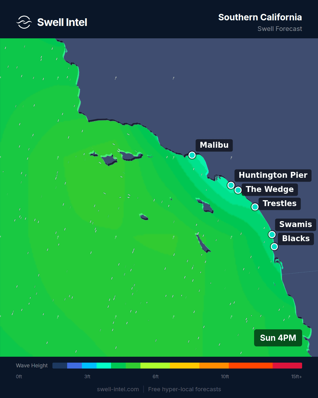
This is the one genuine groundswell on the board. We're reading 15.3 to 15.4 seconds out of 196–204° — south-southwest — at every Southern California spot we track, and that combination in mid-August has one source: a storm that wound up deep in the South Pacific, thousands of miles away, and sent its energy north in a long, well-sorted train. Period is not a cosmetic detail here. A 15-second wave has a deep-water wavelength around 350 meters and carries its energy roughly 175 meters down the water column; an 8-second windswell reaches barely 50. That's why long-period swell feels the reef further out, refracts harder into the right banks, and stands up with real push when it finally breaks. Trestles is the standout at up to 6 ft, with Huntington Pier and Malibu's First Point both up to 5 ft and Cardiff Reef up to 4 ft — all of them rated Good.
And then there's El Porto, up to 2 ft and Poor–Fair on the exact same swell: 15.4 seconds, 202°. That is not a glitch in the data, it's geography, and it's the single most useful thing in this week's forecast. The South Bay's southern window is pinched between the Palos Verdes headland and Catalina Island, and what does slip past arrives at a steep, oblique angle onto a beach that faces west-southwest. Energy that hits Trestles square-on merely grazes El Porto. Four feet of difference over thirty miles of the same coastline, from one swell — that is precisely the kind of split a single offshore buoy cannot show you, because a buoy gives you one number for the entire bight.
On timing, go early. Our ratings for Saturday run 3.3 in the morning window, 1.6 at midday and 1.1 in the afternoon — on our scale, that's a slide from nearly Good down to Poor–Fair over the course of one day, the standard summer pattern where the sea breeze fills in and turns clean lines into texture by lunchtime. Saturday the 22nd is the best day we see, and it sits at the far end of the week, so treat it as a strong signal rather than a locked call. Confidence: high on the swell's period and direction, moderate on peak size and on the exact day. This is long-period energy running onto late-summer sandbars and there's real spread in how much of it stands up — I'd rather quote the conservative number and let the ocean surprise you upward.
Northern California

Surf: 2-3ft • Best day: Wednesday AM • Conditions: Fair-Good
Same swell, different coast — and an even sharper split. Ocean Beach in San Francisco is reading up to 6 ft at Fair–Good on a 15.6-second band from 220°, due southwest. Linda Mar down in Pacifica is up to 2 ft and Poor–Fair on the same 15.6 seconds from 212°. Ocean Beach is four miles of straight, wide-open sand with nothing between it and the open Pacific. Linda Mar sits tucked into a crescent cove behind Pedro Point, and that headland blocks the southern half of its swell window. When the energy arrives from the southwest, that one piece of rock is the difference between a 6 ft day and a knee-high one.
Wednesday is the pick, and the morning is not optional here. Our ratings run 1.1 in the AM, 0.5 at midday and −0.7 by afternoon — the steepest daily collapse of any region this week, from Poor–Fair down through Poor toward Very Poor. That's the Northern California summer thermal doing its work: the inland valleys heat through the morning, the pressure gradient tightens, and the onshore northwesterly turns the coast to washing machine by early afternoon. Dawn until roughly mid-morning is the window. Be honest with yourself about that regional 1.1 average, too — it's dragged down by Linda Mar sitting in the shadow. Ocean Beach is carrying this region on its own.
Which brings the necessary caveat: 6 ft at 15.6 seconds at Ocean Beach is a genuinely serious wave. It's shifty, it's heavy, and the rips on a long-period swell are the real hazard — the paddle-out is usually the hardest part of the session. If you don't already surf OB on groundswell, this is not the week to learn it. Confidence: high on size and direction, moderate on Wednesday specifically holding as the best day.
Pacific Northwest

Surf: 2-3ft • Best day: Thursday AM • Conditions: Fair-Good
The Pacific Northwest has size this week but not much order behind it. We're reading 9.1 to 9.4 seconds from 267–276° — due west — which is windswell out of a weak North Pacific low, not the long-period groundswell California is getting. Nine seconds means the waves are stacked close together, break with less push and give up their shape faster. Indian Beach leads at up to 5 ft and Fair–Good, Cape Kiwanda and Seaside Cove are both up to 4 ft, and La Push up in Washington is up to 3 ft.
Thursday is the best day and the morning the best window, but the margin is thin — 1.9 in the AM against 1.6 at both midday and afternoon. That flat curve is telling you something real: with a west windswell this ordinary, the wind is the forecast. Catch a light offshore or a genuinely glassy morning and 4 ft at Cape Kiwanda is a good session. Catch the usual onshore and it's the same 4 ft, closed out and crumbling. Check the wind the morning of before you commit to a drive out to the coast, because the swell is not going to rescue this one — only the wind can.
New York / New Jersey

Surf: 1-2ft • Best day: Monday PM • Conditions: Fair-Good
Correction, updated Sunday afternoon. This section originally called Tuesday morning as the window. That was wrong, and the reason is worth stating plainly: our automated rating runs on swell height, period and direction, and for these spots it had no wind field attached to it — so it picked Tuesday on period alone (9.2 seconds against Monday's 8.2) without seeing what the wind was doing. On a beach break in August the wind is the forecast. I've re-cut the call by hand against the wind data below. The swell numbers in the original stand; the day and the window were mine to get right and I didn't.
Straight up: this is a small, weak week for New York and New Jersey. We're reading 5.6 to 5.9 seconds from 158–167° — south-southeast — which is locally generated windswell with no groundswell component behind it at all. Six seconds is about as gutless as rideable surf gets. Rockaway and Pacific Blvd out on Long Beach both top out at up to 3 ft, Manasquan at up to 2 ft, and Poor–Fair is the rating on most of it.
Monday afternoon is the only genuinely rideable window this week, and it's a wind story rather than a swell story. Monday starts unsurfable: a strong onshore southeasterly, 24 to 29 mph gusting into the low forties at Rockaway and Long Beach, which will have the whole coast blown to pieces at dawn. Then around 9am the wind swings hard offshore to the northwest and drops to 6–8 mph — and, crucially, it stays offshore for the rest of the day. Through the afternoon it eases further: west-northwest at 9 mph by 4pm on Long Beach, down to 5 mph by 6pm, with Manasquan going almost glassy at 2 mph out of the north-northwest around 5pm. That is six-plus consecutive hours of clean, light offshore wind, and it is the only stretch like it on this coast all week.
Be clear-eyed about what you're paddling out into: the surf drops to 2 ft once the morning pulse fades, so Monday afternoon is small, clean and rideable rather than good. The one Fair–Good reading we have in the whole region is Monday at 9am at Pacific Blvd, at 3 ft — the first hour after the wind flips offshore, while the last of the overnight size is still in the water. If you can only surf one hour this week, that's the hour. If you're working, the 4-to-6pm window is the consolation and it's a real one. Bring volume: longboard, mid-length, fish. This is not a shortboard week on this coast and pretending otherwise would just cost you an evening.
For completeness on why Tuesday is not the call: the wind there is offshore out of the north first thing and genuinely clean between about 10am and noon, but the surf is only 2 ft, and by early afternoon a southerly fills in and builds to 15–22 mph, which finishes it. Tuesday morning is a decent second choice. It is not better than Monday afternoon.
The seasonal turn is coming — mid-August through October is when Atlantic tropical systems start delivering the long-period east and southeast swell this coast actually wants, and it's the difference between 6-second slop and the kind of week that makes the fall worth living here. But there is nothing like that inside this week's window, and I'm not going to invent it. We'll call it when we see it in the model.
New England

Surf: 0-1ft • Best day: Thursday Midday • Conditions: Fair-Good
New England is the quietest region on the board, and that "Fair-Good" conditions label is the most flattering line in this entire forecast — it reflects a single spot's best few hours, not the state of the coast. Typical surf here is 0–1 ft. Narragansett and Misquamicut in Rhode Island are up to 2 ft at Poor–Fair on 5.5 to 6.1 seconds from 168–173°, which is south-southeast slop with nothing behind it. Hampton Beach in New Hampshire is also up to 2 ft, though on a different reading — 8.8 seconds from 119°, east-southeast — which is the first hint of the pattern that matters here. And the "best day" label on Thursday is doing heavy lifting: our three daily windows come in at 0.1, 0.2 and −0.2 — Poor, all day, whichever way you cut it. For most of this coast the honest call is to skip the week.
With one real exception, and it's the most interesting reading anywhere on the East Coast. Nantasket Beach in Massachusetts is up to 3 ft at Fair–Good on 11 seconds from 87° — due east. Eleven seconds is nothing by California standards, but it's roughly double the period anything in Rhode Island is seeing, and it arrives from a completely different direction. Line the region up and the gradient is obvious: Rhode Island on 5.5–6.1 seconds from the south-southeast, Hampton on 8.8 seconds from the east-southeast, Nantasket on 11 seconds from due east. There's distant North Atlantic energy arriving on an easterly line, and how much of it you get depends entirely on whether your beach can see east. Rhode Island can't: the south shore faces south, so due-east swell is ninety degrees off its window, and Cape Cod and the islands sit squarely in the way besides. Massachusetts Bay has a clean easterly window and picks the whole thing up.
So if you're in New England and you want to surf this week, Nantasket around midday Thursday is the one call I'd make. Everywhere else, it's a longboard session at best, and more likely a week to fix your boards and wait for September.
Outer Banks

Surf: 1-2ft • Best day: Thursday AM • Conditions: Poor-Fair
The Outer Banks carries the weakest quality read of the week, which is genuinely unusual for what is normally the best swell magnet on the East Coast. Cape Hatteras is up to 2 ft at Poor–Fair on 5.3 seconds from 52° — a light northeast onshore breeze-swell with nothing behind it. Folly Beach Pier down in South Carolina is up to 2 ft and rated Poor outright, though its 7.6 seconds from 132° at least has a bit more period in it than anything Hatteras is seeing.
Thursday morning is nominally the best window, but read the numbers honestly: AM 0.0, midday −0.1, afternoon −0.5. Zero on our scale is Poor. That is not a recommendation, it's the least-bad hour of a poor week, and I'm not going to sell it as anything else. This is a skip for Hatteras.
The useful thing here is understanding why, because it's temporary. Hatteras sticks further out into the Atlantic than anywhere else on the seaboard and is built for northeast groundswell and tropical swell — it gets both in quantity from September onward, which is when it turns into one of the most consistent stretches of coast in the country. A 5-second local northeast breeze is simply not that. Save the trip and the gas; you'll want both in a month.
Florida East Coast

Surf: 1-2ft • Best day: Saturday Midday • Conditions: Poor-Fair
Florida is small, but it's not as dead as the Carolinas. Cocoa Beach, Sebastian Inlet and Jacksonville Beach are all reading up to 2 ft at Poor–Fair, on 7.5 to 8 seconds from 93–118° — east to east-southeast. Eight seconds is modest, but it is meaningfully more period than the 5-second chop the mid-Atlantic is dealing with, and at Sebastian Inlet that difference actually buys you something: the jetty and the sandbar it maintains take a weak east swell and give it more shape than an open beach can. If you're going to surf Florida this week, that's where to do it.
The timing is worth flagging because it inverts the usual Florida rule. Our best window is Saturday midday — 0.3 in the AM, 0.8 at midday, 0.0 in the afternoon — where normally you'd surf this coast at dawn and be out before the sea breeze. The most likely reading is that the swell is building through the day slightly faster than the onshore is degrading it. Don't sleep in on principle, but don't write off the middle of the day either. Confidence: high on size — this is a well-anchored small-surf call — and moderate on Saturday holding as the best day, since it sits at the far edge of the window.
Puerto Rico

Surf: 0-1ft • Best day: Saturday PM • Conditions: Poor
Puerto Rico is flat, and there's no dressing that up. Maria's in Rincón is up to 1 ft and rated Very Poor; Wilderness up near Aguadilla is up to 2 ft and Poor — the north coast running bigger than Rincón, as it always does. Both are sitting on 6.2 seconds from 64–70°, which is east-northeast trade-wind chop rather than swell in any meaningful sense. Every daily window on the island is negative: −0.6 morning, −0.6 midday, −0.5 afternoon. Saturday PM is the "best" only in the sense that it is marginally the least bad.
This is exactly what mid-August is supposed to look like there, and it's worth understanding rather than being disappointed by. Puerto Rico runs on North Atlantic groundswell: intense winter lows tracking between Newfoundland and Iceland fire long-period north and northwest swell down at the island from roughly October through April, and that is when Rincón and the northwest coast do what they're famous for. In August the North Atlantic is quiet and the only thing moving water is the trades. The one thing that can change that is a tropical system tracking through the right corridor — and there is nothing in this week's window. Come back in October; the island keeps its promises then.
Track it live in Swell Intel
Everything above is what our nearshore SWAN model sees on Sunday morning. A long-period swell six days out will move, and the daily wind windows are the part that shifts most between now and Saturday — so the Southern California call is the one I'd re-check hardest as the week goes on. Swell Intel runs the model continuously into the surf zone, spot by spot, so you can watch Saturday's Trestles window firm up or fade instead of taking a Sunday forecast on faith.
Check the live forecast at swell-intel.com — or set a free alert on your home break and we'll tell you the moment it turns. If you only do one thing with this forecast: if you're in California, keep Saturday morning open.
📱 Get spot-by-spot forecasts, dawn patrol alerts, and buoy-trained ratings in the SwellIntel app.