
Weekly Surf Forecast: August 2-8, 2026
Here is the week ahead — August 2 through 8 — across all eight Swell Intel forecast regions, run through our 50-meter resolution nearshore SWAN model.
The overall read: a modest week with two genuine events in it. The first is Monday on the New Jersey shore — a solid 8-second south swell (NOAA's marine forecast has 7ft at 8 seconds offshore) breaking at 3-4ft with the wind at a workable side-offshore angle. The second is Southern California's building south groundswell: Good-rated mornings from Wednesday on, with a new long-period SSW pulse — 17-to-19- second forerunners are already in the model — filling in Friday into Saturday. Everywhere else stays small: 2-4ft on the West Coast, 1-2ft on most of the Eastern Seaboard, Puerto Rico effectively flat.
The timing story still matters. Nearly every region rates best in the morning, with the rating decaying through the afternoon. The exception worth planning around: Monday on the NY/NJ shore holds its rating all day — Good at Belmar from first light and Good at Manasquan into the afternoon. Everywhere else, this is a dawn patrol week, coast to coast.
Why every region peaks in the morning right now
It is the same mechanism on all four coasts. In August the land heats far faster than the water, and by mid-morning that temperature gradient starts driving an onshore sea breeze. Overnight and at first light the gradient has collapsed, so the wind is light or offshore and the surface is clean. Add a few hours of sun and the breeze fills in, the surface goes to texture, and short-period swell — which is most of what is in the water this week — degrades much faster under wind than long-period groundswell does. Small and clean beats small and choppy, and the difference is usually about three hours.
Confidence: high on Monday's New Jersey window — it is one day out and NOAA's offshore numbers agree with our nearshore model. High on the Southern California build: the incoming pulse's long-period forerunners are already showing in the data, which is the most reliable early signal there is. Lower on the specific East Coast "best day" calls that land on Saturday — six days out, treat those as placeholders and re-check midweek.
Jump to your region:
Southern California

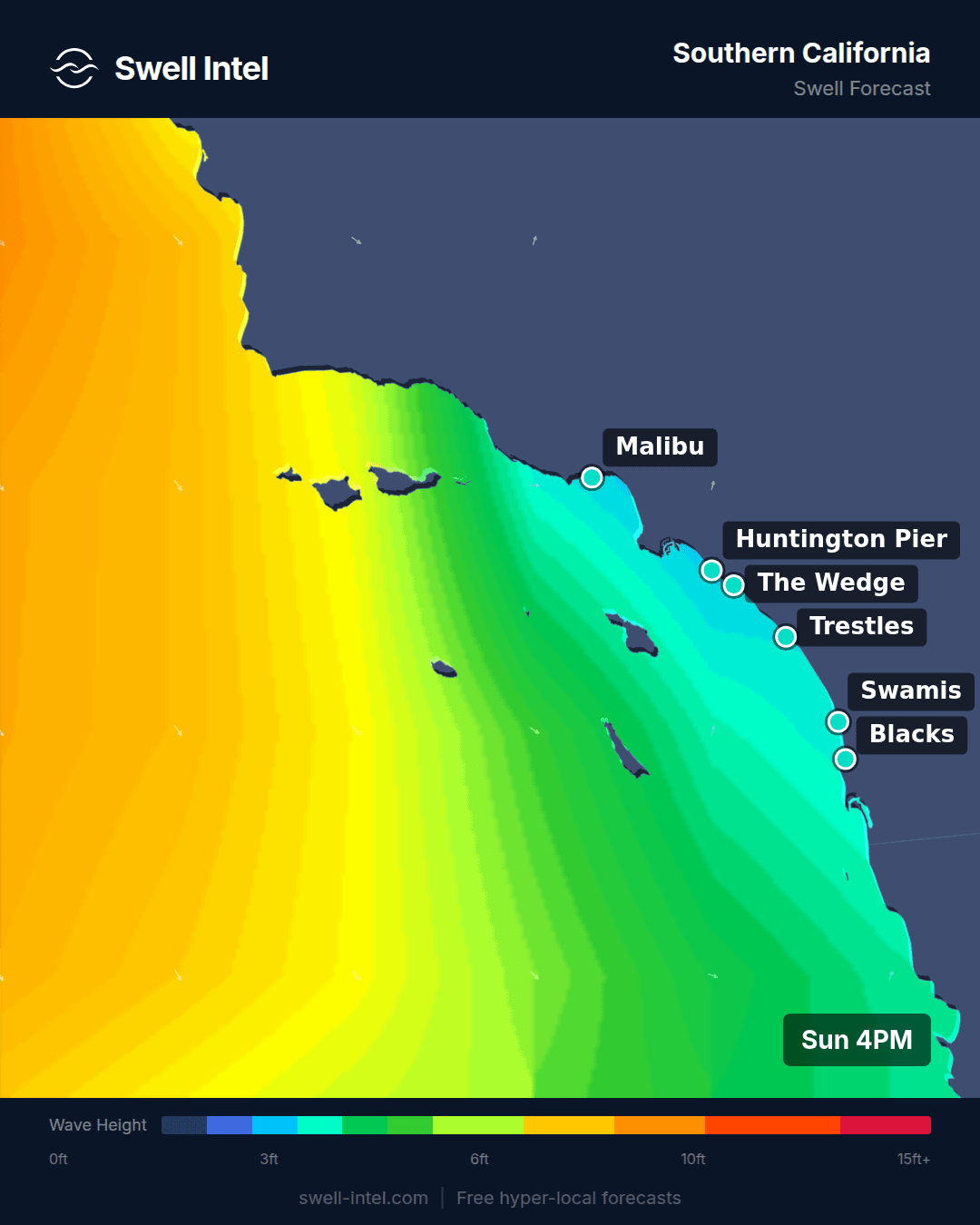
Southern California swell forecast — 50m resolution SWAN model
Surf: 2-4ft, building to 3-5ft Saturday • Best day: Saturday (Aug 8) AM • Conditions: Good mornings from Wednesday on
Southern California is the best region in the country this week, and this run it is not by default — there is real energy arriving. The 12-13 second SSW groundswell that has been feeding Trestles all week holds through midweek, and behind it the model now shows a second, larger Southern Hemisphere pulse: 17-to-19-second forerunners appear in the data Friday and the swell fills in for Saturday. Long-period forerunners showing up this early are the strongest confidence signal a forecast can have.
Trestles is the standout every single day. It rates Fair-Good Monday and Tuesday at 2-4ft, then goes Good every morning from Wednesday through Saturday, building from 3-4ft midweek to 3-5ft on Saturday as the new pulse arrives — the best morning of the week anywhere in the country. Dawn is the window: mornings run light and clean, with the sea breeze softening afternoons all week.
Cardiff Reef runs a notch smaller at 2-3ft and Fair until Saturday, when the 17-second energy pushes it to Good at 2-4ft. Malibu First Point and Huntington Pier ride the same south trains: Malibu has Good mornings Wednesday and Saturday at 2-4ft and an unusual evening peak on Friday, while Huntington holds Fair at 2-3ft building to 2-4ft late week. El Porto stays 1-2ft and Poor-Fair — the throwaway of the group again.
Northern California

Northern California swell forecast — 50m resolution SWAN model
Surf: 2-3ft (Ocean Beach to 4ft) • Best day: Thursday (Aug 6) AM • Conditions: Fair at Ocean Beach — the south pulse arrives at a workable angle midweek
Honest call — Northern California still does not have a good week, but it has a better one than the last model run suggested. The same Southern Hemisphere family feeding Trestles is reaching this coast, and by Thursday it arrives at a workable angle: Ocean Beach reads a 12.6-second SSW train at nearly 4ft that morning, rating Fair at 3-4ft with light wind. That is the region's window. Friday and Saturday hold 2-4ft at Poor-Fair to Fair as the next pulse builds underneath.
Linda Mar is the opposite story: its 9-10 second WNW windswell fades after Sunday and the south energy is shadowed there, so Pacifica spends the week at 1-2ft and Poor. This week, unusually, Ocean Beach is the sensible option and Linda Mar is the skip — but OB at Fair is still OB: shifty, currenty, and a lot of paddling. First light Thursday, bring volume, keep expectations at "session," not "score."
Pacific Northwest

Pacific Northwest swell forecast — 50m resolution SWAN model
Surf: 2-4ft • Best day: Wednesday-Thursday (Aug 5-6) AM • Conditions: Fair — clean offshore mornings are the story
The Pacific Northwest is in its summer lull, but it owns the cleanest mornings in this entire forecast: light northeast — straight offshore — at nearly every spot, nearly every day before the afternoon northwesterly fills in. What is in the water is a mix of 8-second WNW windswell and a persistent 13-to-17-second SW background from the Southern Hemisphere.
The window is midweek. Wednesday, La Push picks up a fresh 8.2-second WNW push at 3-4ft and rates Fair off a glassy offshore morning; Indian Beach goes Fair at 3-4ft Wednesday and again Thursday on the SW background energy. Cape Kiwanda holds 2-4ft at Poor-Fair with offshore mornings all week — rideable daily, special never. Seaside Cove stays the smallest of the four at 2-3ft.
Across all of them the differences are small enough that wind, not swell, decides your session — and the wind says go early. Afternoons drop a full rating class everywhere.
New York / New Jersey

New York / New Jersey swell forecast — 50m resolution SWAN model
Surf: 3-4ft Monday, then 1-2ft • Best day: Monday (Aug 3), all day • Conditions: Good at Belmar and Manasquan, side-offshore SW
Monday is the best single day on the East Coast this week, and it is not close. An 8-to-9-second south swell fills in overnight — NOAA's marine forecast carries 7ft at 8 seconds on the offshore waters — and our nearshore model breaks that at a solid 3-4ft on the Jersey shore, with sets to 4ft. Belmar rates Good from first light; Manasquan reaches Good by mid-morning and holds Fair-Good through the afternoon.
The wind is the honest caveat: it blows Monday — fresh south in the morning clocking southwest 15-20mph through the day. The saving grace is the angle. On this stretch of coast southwest is side-offshore, so the faces hold their shape instead of crumbling; expect texture on the open beach and cleaner walls on anything with a south corner. This is the week's one all-day window — no need to dawn-patrol it, and the afternoon may be the better tide.
Rockaway sees the same pulse a notch smaller and choppier — the swell angle favors the Jersey side.
Tuesday it is gone: back to 1-2ft and Poor nearly everywhere. The leftovers worth a look are at Belmar, which sneaks Fair-Good windows Wednesday mid-morning and Friday at dawn at 2-3ft on 9-second east energy, both with a side-offshore southwest breeze. If you can surf Monday, surf Monday.
New England

New England swell forecast — 50m resolution SWAN model
Surf: 1-3ft in RI, near-flat north of it • Best day: Tuesday (Aug 4) at dawn • Conditions: Fair-Good at Narragansett and Misquamicut, first light only
New England splits hard this week. Rhode Island gets one real window. New Hampshire and Massachusetts effectively get nothing.
The same south swell that lights up New Jersey Monday reaches Rhode Island, but here the Monday wind blows it apart — a 13mph south-southwest sideshore keeps Narragansett at Poor-Fair despite real size in the water. The payoff comes Tuesday at dawn, when the wind drops to nearly calm and the leftover 8-second south energy is still running 3ft-plus offshore: Narragansett Beach and Misquamicut both rate Fair-Good at first light at 2-3ft. It is genuinely a dawn-only call — by midday both slide to Poor and the afternoon is a write-off, the sharpest single-day collapse in this forecast.
North of the canal it stays grim: Hampton Beach and Nantasket Beach sit at 0-1ft and Very Poor essentially all week — there is 8-second east energy in the water, but at under a foot of swell it does not matter. The E/NE swells those beaches need are a fall and winter story.
Outer Banks

Outer Banks swell forecast — 50m resolution SWAN model
Surf: 1-3ft • Best day: Saturday (Aug 8) AM • Conditions: Fair at Hatteras — a placeholder at this range
The East Coast's best swell magnet is idling. Cape Hatteras opens the week at 2-3ft and Poor-Fair on the edge of Monday's south swell — the cape catches a piece of it with a southwest offshore morning breeze — then the middle of the week goes small and windy: 1-2ft with a persistent 12-18mph south-southwester that caps everything at Poor even though there is 10-to-12 second east energy trickling in underneath.
The model's best day is Saturday, August 8: a fresh 8.5-second SE signal brings Hatteras back to 2-3ft and Fair in the morning with the wind finally easing. That is six days out, which is squarely in the range where I treat a specific day as a placeholder rather than a plan. Folly Beach Pier stays 1-2ft and Poor-Fair all week, with the same Saturday uptick a notch smaller. Afternoons rate Very Poor across the region all week.
Florida East Coast

Florida East Coast swell forecast — 50m resolution SWAN model
Surf: 1-2ft, 2-4ft Saturday • Best day: Saturday (Aug 8) AM • Conditions: Fair — offshore mornings all week, east swell for the weekend
Florida's grace this week is the wind: south-southwest — straight offshore for these east-facing beaches — almost every morning. The swell underneath stays modest, 8-second east energy at 1-2ft, so the first five days are groomed-but-small Poor-Fair sessions: rideable at dawn, gone by noon when the sea breeze switches on.
The event is the weekend. An east-northeast swell at 8 seconds builds in Friday night and peaks Saturday morning: Sebastian Inlet goes Fair at 2-4ft — the inlet's sandbars sharpening it as usual — with Cocoa Beach at 2-3ft and Jacksonville Beach at 2-3ft on the same signal. For an East Coast August that is a real window, and the region's best morning average backs it up. The earlier midweek look at Jacksonville has faded out of this run — the weekend swell replaced it, and the model is more confident in the new call than the old one.
Puerto Rico

Puerto Rico swell forecast — 50m resolution SWAN model
Surf: 0-1ft • Best day: Friday (Aug 7) AM • Conditions: Poor — every window of every day rates Very Poor to Poor
Flat. Our model has Puerto Rico at 0-1ft through midweek with every window rating Very Poor to Poor, and only a token 9-second NE trade pulse nudging Wilderness to 1-2ft — still Poor — on Friday and Saturday. There is no surf window here this week, and I am not going to invent one.
That is not a model failure, it is the calendar. The northwest coast runs on N/NW groundswell from North Atlantic winter storms, roughly October through April; in early August that ocean is simply quiet. Wilderness running a touch bigger than Maria's is the usual Aguadilla-over-Rincon pattern, but at these numbers the comparison is academic. If you are booking a trip, book winter. If you are on-island, it is a week for the fins and the mask.
What would change this
Two things are worth watching, and I want to be precise about which of them is a forecast and which is just climatology.
The forecast part: the two in-window events are real and datable. Monday's New Jersey swell is one day out with NOAA's offshore numbers in agreement, and Southern California's Friday-Saturday pulse is announced by 17-to-19-second forerunners already visible in the model — the physics equivalent of a train whistle before the train. If Saturday's East Coast upticks (Hatteras, Sebastian) hold through the Wednesday model runs, they graduate from placeholder to plan.
The climatology part — and this is not a forecast, because no storm exists yet to forecast: Atlantic hurricane season climbs steeply from mid-August toward its climatological peak around September 10. The East Coast's summer diet of small windswell typically ends when the first tropical system spins up far enough offshore to send groundswell without also wrecking the local wind. Nothing like that is in our model window right now. When it shows up, period is the number to watch: the jump from 8 seconds to 12-plus is the difference between a fun weekend and taking the day off. On the West Coast, the Southern Hemisphere window feeding this week's build stays open through September.
Track it live in Swell Intel
Forecasts move, and a seven-day call made on a Sunday is worth less by Wednesday than the model that keeps updating underneath it. Swell Intel runs these regions continuously at 50-meter nearshore resolution, so you get breaking wave height, period and rating at the actual spot rather than an offshore buoy reading that has to be mentally translated to your sandbar. On a week like this one, where the difference between a decent session and a wasted drive is a three-hour wind window, that resolution is the whole game.
Check live conditions and spot-by-spot forecasts at swell-intel.com →
📱 Get spot-by-spot forecasts, dawn patrol alerts, and buoy-trained ratings in the SwellIntel app.