
Weekly Surf Forecast: August 23-29, 2026
Here is the week of August 23–29, 2026, spot by spot. Every height, period and rating below comes out of our own nearshore SWAN model, run at 50-meter resolution right up to the sandbar — not a buoy reading, and not a deepwater number with a fudge factor on it.
The honest overall read: this is a quiet week for most of the country. There are zero active tropical systems in the Atlantic basin — in the last week of August, at the front edge of the climatological peak — and without a storm out there, the entire East Coast is left with local wind chop. Five of our eight regions top out at Poor-Fair, the Pacific Northwest manages exactly one Fair morning, and Puerto Rico is flat for seven straight days. The one genuine bright spot is Southern California, which has Southern Hemisphere groundswell all week and a bigger, longer-period pulse landing next Saturday.
The eastern and central Pacific has three named storms running — Iselle, Lala and Moke — and none of them changes the mainland forecast. Iselle is a 40-knot tropical storm roughly 1,200 miles south of San Diego moving west-northwest at 12 knots: marginal intensity for building swell that survives that distance, and a track that takes it further away rather than closer.
Jump to your region
- Southern California — the only region with Good ratings this week
- Northern California — small and windy
- Pacific Northwest — one Thursday window
- New York / New Jersey — wait for the weekend
- New England — the north shore beats Rhode Island
- Outer Banks — Monday morning, then wind
- Florida East Coast — five days of nothing
- Puerto Rico — flat, no window
Southern California

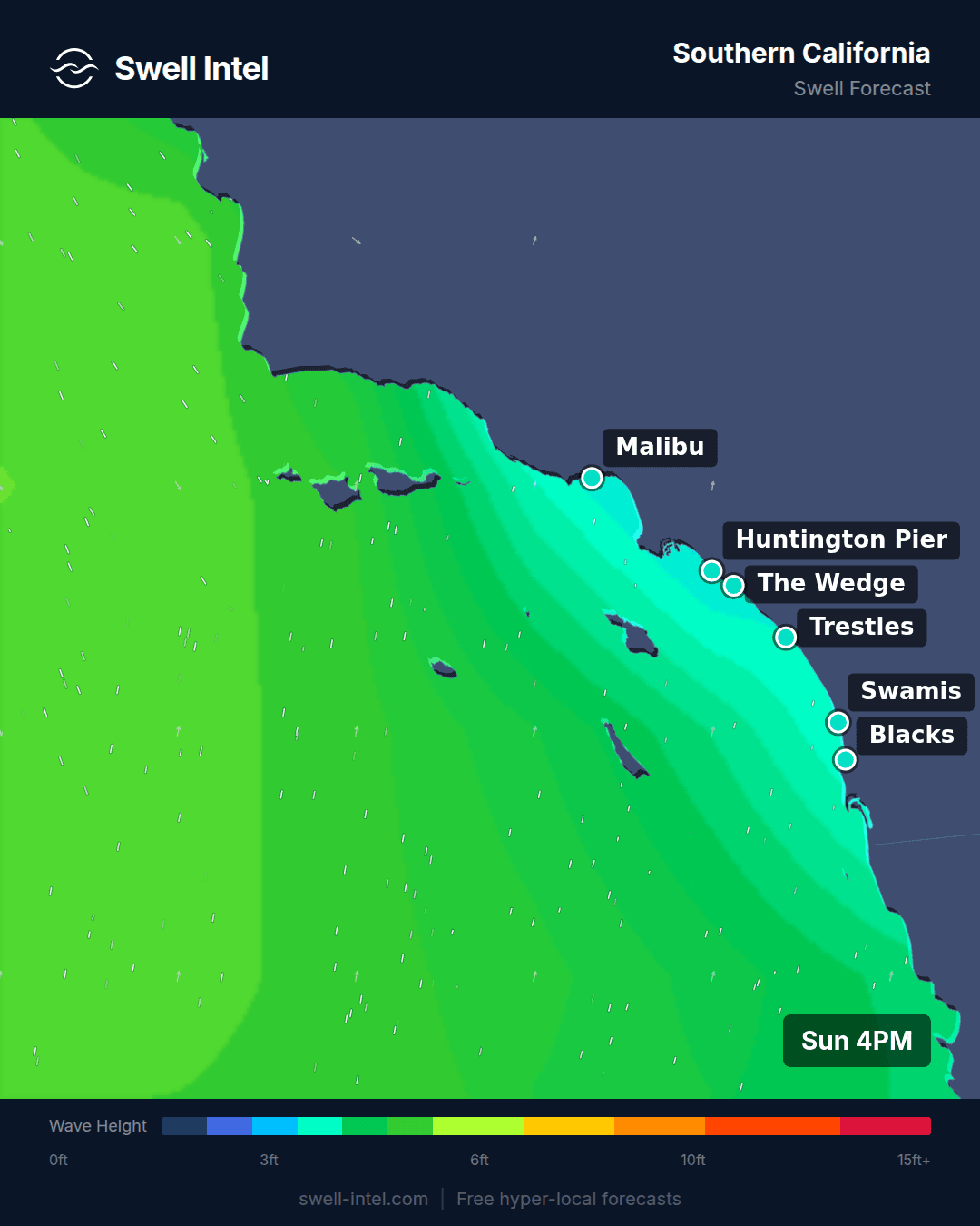
Surf: 2-3ft typical, peak sets 4-5ft • Best day: Thursday the 27th and Saturday the 29th, both AM • Conditions: Good (mornings only)
There is real Southern Hemisphere groundswell in the water and there will be all week. Right now our model has 14 seconds out of 192° hitting the south-swell magnets: Trestles is the standout at 2-4ft with sets to 4, Cardiff Reef is running 2-3ft, and Huntington Pier is 2-3ft with the odd bigger one. That swell is decaying, and you can watch it happen in the period — 14.2s today, 13.2s Tuesday, 12.6s Wednesday, 11.0s Thursday, 9.5s by Friday. Lower period means less energy reaching the sandbar, which is the whole reason period matters more than the height number.
Then it resets. Friday night into Saturday the 29th, a new and longer-period SSW fills in: 17.5 seconds out of 200°, putting Trestles at 3-4ft with sets to 5 and rated Good, and Cardiff at 2-4ft and Fair-Good, both in the morning. We can already see it coming — the secondary swell band at Trestles this morning reads 18.4 seconds from 209°, which is the forerunner edge of that same swell arriving a week early at almost no height. At 17.5 seconds, forerunners move roughly 26 knots, so a 5,000-mile trip takes about eight days: the storm that made next Saturday's waves finished blowing around a week ago. Confidence: high on the swell arriving, moderate on the size and timing — our model's own confidence score drops from 0.85 today to 0.70 by the 29th, and a half-day arrival shift at that range is normal.
Two honest caveats. First, this is a dawn-patrol week, without exception. Most mornings run 3-9 mph and the thermal sea breeze fills in from the W/WSW at 12-19 mph by early afternoon, every single day; ratings typically drop two full grades between 10am and 2pm. Second, not every spot is invited. Malibu First Point averages Poor at 1-3ft, with only brief Fair moments early on Sunday and Thursday, and El Porto is Poor to Very Poor at 1-2ft all week. Both sit in the Santa Monica Bay shadow, where Palos Verdes and Catalina block a 190-200° swell before it ever reaches them. Don't drive to Malibu on this one. And watch Wednesday the 26th: the model shows some of the biggest faces of the week at Huntington, but with a 15 mph SSE wind on it at 8am. That's size without shape.
Worth knowing what the nearshore grid does here that a deepwater buoy cannot. This morning the offshore swell is 194° at 14 seconds, but by the time it reaches the Cardiff reef our model has it refracted around to 242° — a 48-degree bend from bathymetry alone. Huntington bends 184° to 212°. Trestles barely bends at all. Same swell, three different waves, and it is why a south swell reads completely differently a few miles up the coast.
Northern California

Surf: 1-2ft typical, peak sets 3-4ft • Best day: Wednesday the 26th, AM • Conditions: Poor to Poor-Fair
It is not going to be good up here this week, and there is no window worth rearranging your schedule for. Ocean Beach holds the only real size — 2-3ft, building to 4ft by Saturday — and it is rated Poor to Poor-Fair on every day of the forecast. Linda Mar is worse: 1-2ft and Poor all week, sliding to Very Poor on Saturday. The best single window in seven days is Wednesday morning at Ocean Beach, and even that is a Poor-Fair.
The mechanism is straightforward. The primary energy is short-period W/WNW windswell — 6.5 to 8 seconds out of 280-295° — which is locally generated slop, not travelled swell. The same Southern Hemisphere groundswell feeding SoCal does reach here (our model picks up 15-17 second bands from 213-236° on Monday and Wednesday), but a SW angle is a bad match for beaches that face W/NW, and the little that gets in is buried under the wind chop. Then the afternoon onshore does the rest: 14-22 mph W/WNW by mid-afternoon most days, with Saturday the 29th hitting 22 mph at Ocean Beach. Every day is a dawn window or nothing.
If you are going, go early, go to Ocean Beach, and expect a workout rather than a session. This is a longboard-and-coffee week for Pacifica.
Pacific Northwest

Surf: 1-2ft typical, peak sets 3-4ft • Best day: Thursday the 27th, AM • Conditions: Fair (one day)
Small, but with one clear window. Thursday the 27th is the day: Indian Beach comes in at 2-4ft rated Fair, the only Fair rating in the region all week, with 7-8 second W energy from 275° and a light 7 mph SSE wind in the morning — cross-offshore for a west-facing beach. Cape Kiwanda and Seaside Cove both run 2-3ft the same morning, and La Push is 2-3ft Poor-Fair. That is the whole highlight reel.
Around it, the week is Poor. Tuesday and Wednesday bring 16-22 mph S/SSW winds through the Oregon and Washington coasts — La Push drops to Very Poor on Wednesday under an 18-22 mph SSE wind. There is a genuine long-period band mixed in midweek (13.7-14.8 seconds from 258-262° at Seaside and Kiwanda on Wednesday, the far northern edge of that same south-swell train), but at 1-2ft breaking, the period is more interesting than useful.
Saturday the 29th brings a 13-16 second WSW pulse to Cape Kiwanda that keeps building into Sunday. It is only Poor-Fair inside the forecast window, so we are not calling it — but if you are looking past this post, that is where to look.
New York / New Jersey

Surf: 1-2ft • Best day: Saturday the 29th, AM • Conditions: Poor-Fair
Small and mushy, and for most of the week not worth the parking. Rockaway is Very Poor from today through Thursday and Pacific Blvd is barely better — 1ft at 4-7 seconds, which is chop, not surf. Manasquan is the exception and the pick of the region: it holds Poor-Fair most days at 2ft, because it faces further east and picks up energy the New York beaches simply cannot see around Long Island.
The one quality window is Tuesday the 25th at Manasquan: 2ft at 11 seconds from 118°, with a W to WNW offshore at 11-19 mph. Eleven seconds is travelled energy rather than local chop, and it carries far more push than the 2ft at four seconds you get the rest of the week — it will stand up and break with some authority instead of crumbling, and the offshore will groom the face. Don't expect period alone to hand you shape, though. Long-period swell refracts as it shoals and arrives with its crests lined up parallel to the beach, so on an open stretch of Jersey sand 11 seconds squares up and closes out. Shape comes off the bottom, not out of the swell: the corners, whatever the bars are doing, and the structure around the inlet are what turn this into a makeable wave. The difference between travelled swell and wind slop is exactly what to read for in the Mid-Atlantic.
Thursday the 27th is the day to write off entirely: 19-29 mph S/SSE onshore, everything Poor or worse. That wind does some work for you, though. It builds a short-period SE windswell, and when the wind swings offshore Friday and Saturday morning, the leftovers clean up into a rideable, waist-high Poor-Fair. Saturday the 29th, first light, light SSW to NW wind — that is the best the region gets, and it is still a longboard call.
New England

Surf: 1-2ft • Best day: Saturday the 29th, AM • Conditions: Poor-Fair
A quiet, sub-par week, but the split between the two halves of the region is worth understanding. The Massachusetts and New Hampshire beaches are the better play: Nantasket Beach is Poor-Fair on six of seven days at 1-2ft, and Hampton Beach is Poor-Fair from Wednesday onward. Both are seeing 8.5-10.9 second energy out of the east (88-118°) — small, but travelled, and squarely in the window those E/NE-facing beaches want.
The Rhode Island spots are the ones to skip. Narragansett and Misquamicut face S/SE and are shadowed from due-east energy by Long Island and Block Island, so what reaches them is 6-second local slop from 170-180°. Both hit Very Poor on Sunday and Tuesday, and neither gets above Poor-Fair at any point in the week. There is a 10-12 second SE band showing on Sunday and Tuesday at Misquamicut, but it is arriving at 1ft — the angle is there, the size is not.
Best window: Saturday the 29th at first light, when Hampton and Narragansett both come up to Poor-Fair under a light NNW offshore (4-7 mph). Thursday morning at Nantasket is the second-best option. Everything else this week degrades hard after 11am as the SW sea breeze builds to 15-22 mph.
Outer Banks

Surf: 1-2ft • Best day: Monday the 24th, AM • Conditions: Poor-Fair
Cape Hatteras has the cleanest swell signal on the entire East Coast this week — 8 to 12.5 seconds out of 97-109°, which is real travelled energy from a distant mid-Atlantic fetch rather than local chop. The problem is that it arrives at 1-2ft, and then the wind gets involved.
Monday the 24th, early, is the window: 2ft, 11.7 seconds from 108°, with a light 8 mph WSW offshore. Take it, because it closes fast. Tuesday brings a 15 mph SE onshore, Wednesday a 22 mph easterly, and then Thursday through Saturday the region gets buried under a sustained SW wind — 33 mph on Friday the 28th, holding near 30 mph through Saturday. That is technically offshore for an east-facing coast, but at that strength it does not groom a 2ft wave, it destroys it. Ratings sit at Poor.
Folly Beach down in South Carolina is a straight skip: 4-5 seconds out of 180°, rated Poor or Very Poor on all seven days, with 15-25 mph SW onshore most afternoons. There is no window there this week.
Florida East Coast

Surf: 0-1ft • Best day: Friday the 28th, AM • Conditions: Poor-Fair
Five straight days of nothing. Cocoa Beach, Sebastian Inlet and Jacksonville Beach are all rated Very Poor from Sunday through Thursday — not small-but-rideable, but ankle-high, 1ft on most of them. This is the direct cost of an empty Atlantic: Florida runs on tropical swell and cold-front northeasters, and in late August with no storm anywhere in the basin, there is simply no source.
The week's only real improvement comes Friday the 28th at dawn. Cocoa Beach comes up to 2ft at 8.5 seconds from 85° under a 4 mph SSW — light offshore, glassy, and genuinely rideable for a longboard. Sebastian Inlet is the more interesting reading that morning: 11.8 seconds out of 72°, the longest-period swell the region sees all week. Still only 2ft, but at that period on Sebastian's sandbars it will have some push. Saturday morning at Cocoa repeats it at 8 seconds.
Both windows are gone by 11am. Onshore E/ESE builds to 12-20 mph every afternoon and drops everything back to Very Poor. If you are not out by 8, don't bother.
Puerto Rico

Surf: 0-1ft • Best day: none • Conditions: Very Poor
Flat. There is no soft way to put this one: our model has Maria's and Wilderness at 1ft and Very Poor for every daylight hour of every day this week. Not one window, not one morning. Skip it.
That is the season doing exactly what the season does. Rincon and the Aguadilla coast run on N/NW groundswell from North Atlantic winter storms, which is an October-through-April business. What is arriving now is trade-swell out of the northeast — 9-10 seconds from 37° at Maria's — and the trades are strong this week, 23-31 mph ENE at Wilderness on Thursday. Strong enough to be uncomfortable, nowhere near the right direction to make a wave.
Worth noting for when it does turn on: the northwest-facing beaches near Aguadilla run noticeably bigger than Rincon on the same swell, often 6-8ft when Rincon is 4-6ft. Rincon is the quality play a couple of feet smaller. Set an alert and come back in October.
The week in one line
Southern California is the only region in the country with Good ratings, and the play is dawn patrol at Trestles, Cardiff or Huntington — today, Thursday, and best of all next Saturday when the 17-second swell lands. Everywhere else, mornings only, and mostly one marginal window per region. The Atlantic being empty in the last week of August is unusual, and it will not stay that way — when it changes, it will change fast.
Track it live in Swell Intel
Weekly forecasts age. Our nearshore SWAN model updates continuously at 50-meter resolution for every spot named above — breaking height, period, direction and rating, hour by hour, plus dawn patrol alerts when your spot comes good. Check the live forecast at swell-intel.com, or start with how to read a surf forecast if the numbers above are new to you.
📱 Get spot-by-spot forecasts, dawn patrol alerts, and buoy-trained ratings in the SwellIntel app.