
Weekly Surf Forecast: September 6-12, 2026
Every number below comes out of our own nearshore SWAN model — a 50 m grid that carries the swell the last few miles and breaks it on the actual sandbar, rather than reading a buoy parked 20 miles offshore and hoping. That distinction matters a lot this week, because the raw heights are lying to you in half these regions.
Honest overall read for September 6–12: this is a one-coast week. Southern California has a real long-period south swell — 12 to 15 second energy out of the Southern Hemisphere, and it is the only groundswell in the country worth rearranging your schedule for. Northern California gets a smaller, wind-limited piece of the same storm. Everywhere else — the Pacific Northwest, the whole Eastern Seaboard, and Puerto Rico — is running on 4 to 8 second local windswell at 1 to 3ft. It is peak Atlantic hurricane season and there is nothing tropical in our model window this week. That can change fast in September; right now it hasn't.
Jump to your region
- Southern California — the standout
- Northern California
- Pacific Northwest
- New York / New Jersey
- New England
- Outer Banks
- Florida East Coast
- Puerto Rico
Southern California

Surf: 3-4ft • Best day: Sunday PM • Conditions: Good
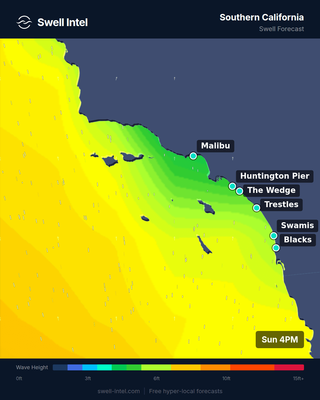
This is the week's one legitimate swell. Our grid runs 12.6 to 14.9 second energy into the whole bight from 177–189° — due south to a hair west of south, which is the signature of a Southern Hemisphere storm that has spent a week crossing the Pacific. Trestles is the standout, peaking near 8ft on our model at the top of the swell, with Malibu First Point and Cardiff Reef both running up to 6ft and Huntington Pier up to 5ft. Read that 8ft as the ceiling, not the average: most of the region sits in the 3-4ft band through the week, and the sets that actually touch the model's peak will be infrequent. High confidence on the swell showing up and on the period; moderate confidence on the top-end size.
Timing is the part worth planning around, and it runs backwards from the usual SoCal script. Our ratings are weakest in the morning, improve through midday, and peak in the afternoon — the swell is still filling in through the day rather than sitting at full height at dawn, so the customary get-there-at-sunrise instinct is the wrong call this time. Sunday afternoon is the best window of the week anywhere in the country. If you can only surf once, that's it.
Direction explains the spread between spots. South-facing setups eat this swell: Malibu is a south-facing point and lights up on exactly this angle, Trestles sits wide open to due south, and Cardiff takes it clean. El Porto is the outlier at 3ft and only Fair — it carries the longest period in the region at 14.7 seconds, but it sits up in Santa Monica Bay behind the Palos Verdes peninsula, and due-south energy has to bend around that headland before it ever reaches the sand. Long period helps it wrap; it doesn't undo the shadow. Don't drive to El Porto on a south swell and blame the forecast.
Northern California

Surf: 2-3ft • Best day: Monday AM • Conditions: Fair-Good
Same storm, longer road. The south swell reaches the Bay Area at 15.1 seconds out of 202–214° (SSW to SW) — the longest period we're modelling anywhere this week — but it arrives smaller and considerably more selective. Ocean Beach is the play at up to 5ft and Fair-Good, sitting fully open to the southwest window. Linda Mar is not: 2ft and Poor-Fair. Pacifica tucks in behind Pedro Point, which is exactly the wrong geometry for a SW angle, so the swell that's making OB work walks straight past it. That's a longboard session at best.
Wind decides everything else. Our ratings are respectable at dawn, fall off by midday, and are effectively gone by the afternoon as the sea breeze fills in — a sharper day-to-day collapse than SoCal's. Monday morning is the pick, and the emphasis is on morning. If you're not in the water early you're surfing a different, worse ocean. Moderate confidence overall: the swell is real, but at 2-3ft nearshore the margin between a clean session and a wasted drive is one wind shift wide.
Pacific Northwest

Surf: 2-3ft • Best day: Saturday AM • Conditions: Fair-Good
The heights look fine and the period tells the real story. Indian Beach tops out at 5ft, with Seaside Cove, Cape Kiwanda and La Push all around 4ft — but all of it is arriving at 8.2 to 8.5 seconds from 295–301°, and that is locally-generated windswell off the North Pacific, not groundswell. Eight-second energy stacks up short and steep with very little gap between waves, so expect a rough, closely-spaced, workmanlike ocean rather than lined-up walls. It's rideable. It isn't the reason you own a 5/4.
Mornings are meaningfully better than the rest of the day across all four spots, and Saturday the 12th is the strongest day in our window. Indian Beach and La Push carry the best ratings of the group; Seaside Cove and Cape Kiwanda are a step down at Fair. Everything here hinges on wind — with a period this short, texture is the whole game, and any onshore breeze turns it to mush immediately.
New York / New Jersey

Surf: 1-2ft • Best day: Friday AM • Conditions: Fair-Good
It's small. Set the expectation now. Rockaway, Manasquan and Pacific Blvd all top out around 3ft, but the period is 5.5 to 5.9 seconds from 85–91° — that's due east, and at that period it is straight local windswell with no groundswell character at all. In practice that means knee-to-waist, fast, and closing out on anything but a well-shaped bar. The Fair-Good conditions rating is about cleanliness, not size: this will be tidy, small surf, which is a genuinely different thing from good surf.
Take the mornings. Our ratings are clearly best at dawn and decline through the day at all three spots, and Friday morning is the cleanest window of the week. It's a longboard, fish, or foamie week — and an honest one to skip if your quiver starts at 6'0".
Worth naming the elephant: it's the second week of September, statistically the sharp end of Atlantic hurricane season, and our model window shows no tropical swell reaching the Mid-Atlantic in this period. That's what the physics says today. September being September, a week is a long time — but we're not going to sell you a storm that isn't in the data.
New England

Surf: 1-2ft • Best day: Friday AM • Conditions: Fair-Good
This is the weakest region in the country this week, and there's no window that rescues it. Unlike everywhere else on this page, our ratings are flat from dawn to dark — there's no clean morning to target, just a slightly-less-bad Friday. Misquamicut is effectively flat: 2ft at 3.3 seconds, which is wind ripple rather than surf. Call it and save the gas.
What's there splits by aspect. Nantasket Beach is the biggest at up to 4ft and Hampton Beach up to 3ft, both fed by 6.8 second energy from 51–67° (NE to ENE) — the east and northeast-facing Massachusetts and New Hampshire beaches are the ones actually catching this. Narragansett picks up a separate, smaller 5.6 second pulse from 184° (due south) for up to 3ft, which is the south-facing Rhode Island shore doing its own thing. Neither source is strong. Friday morning, lowest expectations you own, and a board with volume.
Outer Banks

Surf: 2-3ft • Best day: Thursday AM • Conditions: Fair-Good
The Outer Banks is the cleanest illustration of why we lead with period instead of height. Cape Hatteras models up to 4ft — at 4.1 seconds, out of 37° (NE). Four feet at four seconds and four feet at fourteen seconds are not the same ocean and not even close; wave power scales with the square of the height and with the period, so a short-period swell carries a small fraction of the punch at the same nominal size. Expect weak, fast, closing-out surf that looks bigger on a forecast table than it feels under your feet. Folly Beach Pier is the better of the two at up to 4ft on a longer 5.7 second period from 158° (SSE) — still short, but with enough spacing to give the sandbars something to work with.
Mornings only. Our ratings drop off hard after midday and are close to worthless by the afternoon, so Thursday at dawn is the call and there isn't a credible second option. Hatteras sits further out into the Atlantic than anywhere else on the East Coast and will be the first to know when something real arrives — this week, it just hasn't.
Florida East Coast

Surf: 1-2ft • Best day: Wednesday AM • Conditions: Fair-Good
Small, but with the best-quality energy on the Eastern Seaboard this week. Our model has 7.4 seconds running into the whole coast from 76–108° — the longest period anywhere on the Atlantic side, which is a low bar but a real one. Jacksonville Beach rates best at up to 3ft and Fair-Good, helped by taking the swell from 108° (ESE) rather than square-on east. Cocoa Beach and Sebastian Inlet both hit 3ft but only rate Fair, and the regional average is 1-2ft, so be realistic — this is a waist-high week on the Space Coast, not a Sebastian week.
Wednesday morning is the pick, with the usual Florida pattern: cleanest early, degrading as the sea breeze establishes. Sebastian Inlet is the quality spot in this region whenever there's actually swell to work with, and at 7.4 seconds and 1-2ft there mostly isn't. Longboard, and go early.
Puerto Rico

Surf: 1-2ft • Best day: Thursday AM • Conditions: Good
September is the off-season here and the model shows it — 1-2ft regionally, on 4.7 to 7.7 second energy from 51–67° (NE to ENE), which is trade-wind swell rather than the North Atlantic groundswell the island is famous for. The winter season that turns Rincón and Aguadilla into a destination runs roughly October through April on N/NW swell; we're a few weeks early. Wilderness is the clear pick at up to 4ft and rating Good, taking the longer 7.7 second period on its north-facing exposure near Aguadilla. Maria's is smaller and only Fair at up to 3ft on a weak 4.7 second period — that west-facing Rincón angle needs a north or northwest swell to come alive, and this isn't one.
Timing is unusually sharp and worth respecting: our ratings are strong in the morning, collapse almost completely by midday as the trades fill in, then partially recover late. Thursday morning, early, is the window — and treat it as a genuine window rather than a suggestion, because the midday drop-off here is the steepest we're modelling anywhere this week. Small, but clean and warm, and the north coast is the side to be on.
Track it live in Swell Intel
Forecasts move, and a week is a long time — particularly in September, when the Atlantic can spin something up faster than any weekly outlook can follow. Open Swell Intel to watch our nearshore SWAN model update in real time for every spot above: breaking wave height on a 50 m grid, period, direction and confidence, so you can see a swell coming before it shows up on a buoy.
📱 Get spot-by-spot forecasts, dawn patrol alerts, and buoy-trained ratings in the SwellIntel app.