
Weekly Surf Forecast: August 9-15, 2026
Here is the week of August 9–15 across all eight Swell Intel regions, run through our 50-meter resolution nearshore SWAN model — the grid that takes deep-water swell and refracts it onto each individual point, reef and sandbar instead of handing you one number for an entire coastline.
The honest read: this is a one-region week. Southern California has a genuine 15-second Southern Hemisphere groundswell in the water and is the only place in the country worth rearranging a schedule for. Everything else is small. The entire Atlantic seaboard from Jacksonville to New Hampshire tops out around 2ft, the Pacific Northwest is running on short-period local windswell with no groundswell behind it, and Puerto Rico is sitting in the middle of its trade-swell offseason. We will still tell you where the best hour is in each of those regions, because there usually is one — but we are not going to dress up ankle-high surf as something to plan a week around.
One pattern shows up almost everywhere and is worth leading with: mornings beat afternoons, coast to coast. Southern California's average morning rating in this run is more than three times its afternoon rating. Northern California, Florida and the Outer Banks all decay the same way through the day. That is mid-August thermal sea breeze doing exactly what it does — the land heats up, the onshore gradient builds through late morning, and whatever texture the surface had at dawn is gone by lunch. If you get one session this week, take the early one.
A note on how to read the summary lines below. The Surf figure is the region's typical band across the week's daylight hours, not its peak; individual spot numbers are that spot's best hour. The Conditions tag is the best rating the model produced anywhere in the region all week — a single good hour at one spot earns it, so treat it as a ceiling rather than an average. If you want the full explanation of how period and direction drive all of this, we wrote it up in how to read a surf forecast.
Jump to your region
- Southern California — the only region with real swell
- Northern California
- Pacific Northwest
- New York / New Jersey
- New England
- Outer Banks
- Florida East Coast
- Puerto Rico
Southern California

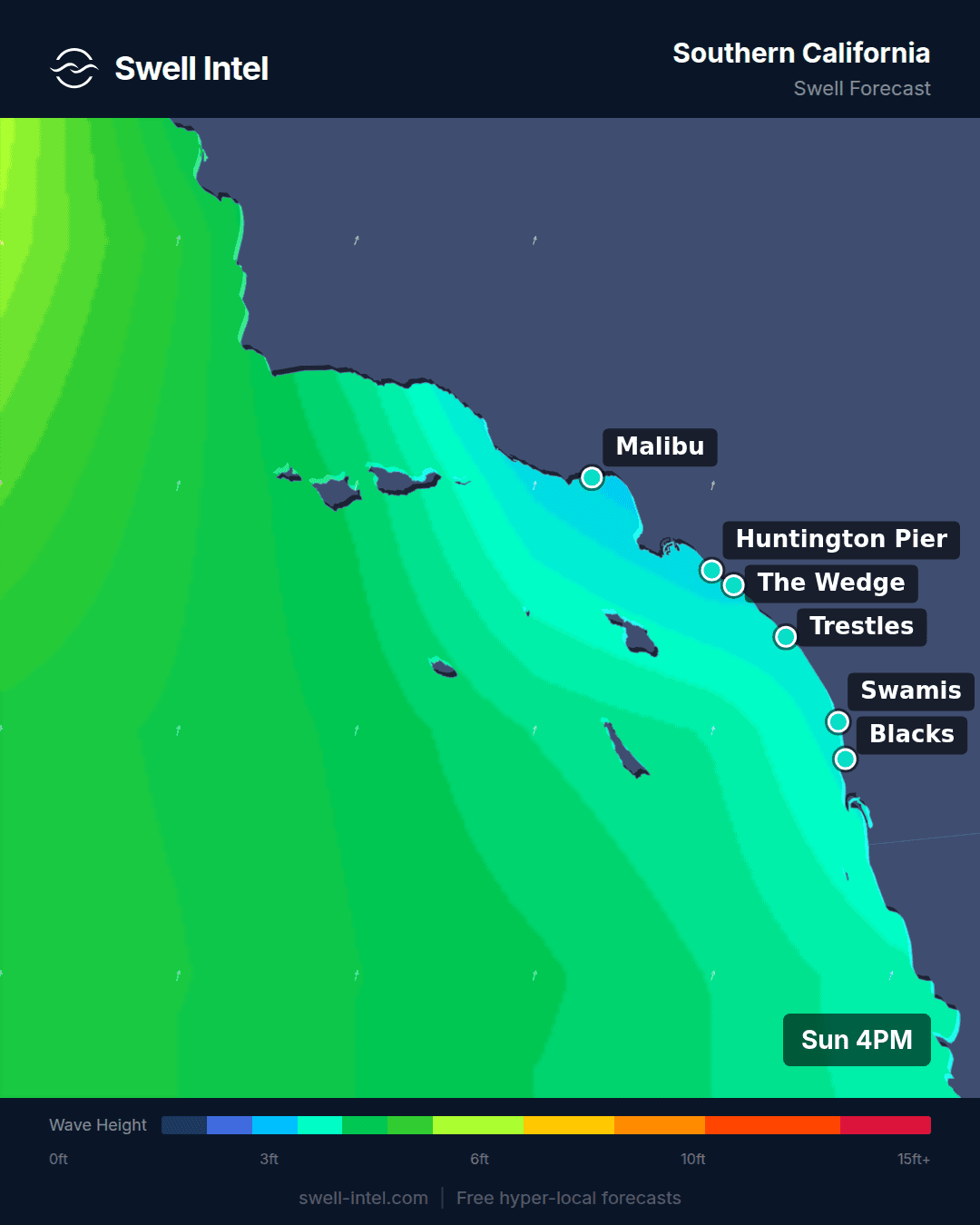
Surf: 2-4ft • Best day: Sunday AM • Conditions: Good
The energy here is Southern Hemisphere groundswell, and the numbers are unambiguous: our model has the primary swell at 15.4–15.5 seconds out of 192–199°, a hard SSW line that points back into the Southern Ocean. A swell with that period and that direction in August was made by a storm in the New Zealand and Tasman sector roughly a week ago and several thousand miles away. Everything short-period fell off during the transit, so what arrives is well-sorted, evenly spaced and hits with more push than its height suggests. This is the swell SoCal waits all summer for, and it is right on schedule for the season.
That angle sorts the coast fast. Trestles and Malibu First Point are the standouts at up to 6ft, with Huntington Pier and Cardiff Reef just behind at up to 5ft — all four are S/SW-facing setups with cobble or reef underneath, the kind of bathymetry that lets a long-period SSW wrap in and stand up rather than close out. El Porto is the outlier at 3ft and Fair: it is a straight, west-facing beach break inside Santa Monica Bay, and a 197° swell arrives there at a poor angle with Palos Verdes taking a bite out of the southern approach. Same swell, half the size, twenty miles apart. That spread is precisely what a single offshore buoy cannot tell you, and it is the reason we run a nearshore grid instead of quoting one deep-water number for the whole region.
Timing is decisive: mornings. The best-rated window in this entire eight-region run is Sunday morning — which is to say right now, as this publishes — and the ratings fall off sharply from midday onward as the sea breeze fills in. The fact that the model's top-rated day is today rather than midweek also tells you something useful: this swell is at or near its peak rather than building, so treat the front half of the week as the window and expect it to ease rather than grow. Confidence is high on size and direction — long-period groundswell already in the water is the easiest thing we forecast — and lower on exactly how quickly it backs down.
One to watch, not to plan around. The East Pacific is finally stirring. As of Sunday morning the National Hurricane Center is tracking a disturbance a few hundred miles southwest of the Baja tip with a medium chance of developing over the next seven days, plus a second area off southwestern Mexico later in the week. If something does spin up and track northwest with a workable fetch, the earliest Southern California would feel it is the very back end of this window, and more likely the week after. That is a watch item at low confidence — we call these when the fetch is real, not when the map looks interesting. Our previous East Pacific hurricane swell breakdown covers how these systems actually deliver to SoCal.
Northern California

Surf: 2-3ft • Best day: Saturday AM • Conditions: Good
Northern California is a tale of two spots this week, and the gap between them is the whole story. Ocean Beach in San Francisco tops out at up to 7ft and is the reason the region carries a Good tag at all; Linda Mar in Pacifica, a dozen miles down the coast, peaks at 2ft and rates Poor-Fair. Ocean Beach faces W/NW with nothing between it and the open North Pacific, so it takes everything on offer; Linda Mar sits tucked into a cove that needs considerably more swell before it wakes up.
Be careful what you read into that 7ft. The swell mix in play at the start of this window is short-period — around 8 seconds, from a mixed S and WNW direction, which is local-fetch windswell rather than organized groundswell. Seven feet of eight-second energy at Ocean Beach is not a session, it is a paddle: shifting peaks, closeouts, and a long swim if you get it wrong. The size is genuinely there and the quality is not, and OB is not the place to find that out the hard way. The region's Good rating comes from one strong hour at one spot, not from the week.
Mornings are the play again, and the morning-to-evening collapse here is the steepest in the country — our average rating drops from 2.5 in the morning to 0.2 by evening as the northwest sea breeze gets to work. The model's best-rated day lands on Saturday, six days out; at that lead time, and with the day-to-day differences this small, treat that as a soft signal rather than a plan. Worth re-checking midweek.
Pacific Northwest

Surf: 2-3ft • Best day: Saturday AM • Conditions: Fair
The Pacific Northwest is quiet, and one number explains it: our model has the primary swell at 5.6 to 5.8 seconds out of 297–324°, NW to WNW. Anything under about six seconds is wind sea — water still being pushed around by nearby wind, not swell that has travelled far enough to sort itself into lines. The North Pacific is in its August minimum and there is no storm track worth the name to feed the coast.
On the ground that means Indian Beach is the biggest at up to 4ft, with Cape Kiwanda, Seaside Cove and La Push all around 3ft, and Fair is the ceiling for the whole region. Small, weak and short-period: surfable if you live there, not worth the drive from Portland or Seattle. A longboard or a fish will get more out of this than anything else in the quiver.
Mornings edge out evenings, though morning and midday are effectively tied in this run, and the model's nominal best day is Saturday at the far end of the window. With every day sitting in the same narrow band, that pick is noise — do not build a weekend around it. Up here wind decides more than swell does anyway, and at these periods it will decide everything.
New York / New Jersey

Surf: 0-1ft • Best day: Thursday AM • Conditions: Poor-Fair
We will be direct: New York and New Jersey are flat this week. The regional band is 0-1ft. Rockaway, Manasquan and Pacific Blvd peak around 2ft at their absolute best, and Rockaway rates Poor outright. The swell reads about 6 seconds out of 158–169° — south to south-southeast, short-period, which is sea-breeze chop that never got the fetch to become anything more.
The reason nothing is coming is worth knowing, because it is the thing that will eventually change. There is no tropical engine running. As of Sunday morning the Atlantic outlook carries two tropical waves: one several hundred miles west-southwest of the Cabo Verde Islands, and another expected to move off West Africa early in the week. Both sit three to four thousand miles from the Mid-Atlantic, and even on the high end of their development odds, nothing they produce reaches New York or New Jersey inside this window. Mid-August without a storm means the region runs purely on local windswell — and this week the local wind is not cooperating either.
The model's best window is Thursday morning, but the honest caveat is that its average rating there is still fractionally below Poor. That is not a reason to take the day off work. This is a week to fix your dings, get in the water on a longboard if you just need the salt, and watch the tropics — the season that fixes this is only a few weeks out. Full regional detail lives on our New York and New Jersey forecast pages.
New England

Surf: 0-1ft • Best day: Tuesday Midday • Conditions: Poor-Fair
New England is in the same hole, for the same reason. Narragansett Beach, Misquamicut, Hampton Beach and Nantasket Beach all peak at 2ft, all rate Poor-Fair, and the regional band is 0-1ft. There is nothing here worth a tank of gas.
The one flicker of structure is at Hampton Beach, where the primary swell reads 8.5 seconds out of 110° — an ESE direction with just enough period to suggest it travelled a little. Hampton and Nantasket face E/NE, so an ESE line is at least aimed at them, while the Rhode Island beaches are working with a 6-second south wind chop that Narragansett and Misquamicut need far more of before they turn on. Nantasket's own reading is under two seconds out of the WNW, which is a straight offshore breeze with no fetch behind it and no wave to speak of.
The best-rated window is Tuesday midday rather than dawn, which is unusual for August — mostly because there is so little swell here for the sea breeze to ruin. Low confidence and low stakes either way: check the day before you commit, and go in expecting a longboard session, not a surf.
Outer Banks

Surf: 1-2ft • Best day: Friday AM • Conditions: Poor-Fair
The Outer Banks is the best of the eastern seaboard this week, and this week that is a low bar. Cape Hatteras peaks at 2ft and rates Poor-Fair; Folly Beach Pier peaks at 2ft and rates Poor. The regional band is 1-2ft. The swell is 7.1–7.5 seconds out of 129–135°, a SE direction — better organized than what New York and New England are getting, and pointed straight into the E/SE-facing Carolina coast, which is why Hatteras takes the regional nod.
Hatteras earns that in the usual way: Cape Point juts further into the Atlantic than anything else on the East Coast, so it collects swell that expires before it reaches the beaches north and south of it. In a week like this that only helps in relative terms — with a weak SE windswell running, the Point is the one place in the region where 2ft is likely to be clean enough to link two turns together. It is still 2ft. If you want the full mechanics of why that headland does what it does, we broke it down in how the Outer Banks bends swell into barrels.
Best window is Friday morning, and the Outer Banks carries the clearest morning bias on the East Coast in this run: the model rates mornings four times better than midday, and by evening the rating is flat zero. That is the sea breeze, again. Confidence on Friday specifically is low at five days out; confidence that mornings beat afternoons every day this week is high.
Florida East Coast

Surf: 0-1ft • Best day: Monday AM • Conditions: Poor-Fair
Florida is flat. The regional band is 0-1ft, Cocoa Beach rates Poor, and Sebastian Inlet and Jacksonville Beach both peak at 2ft with a Poor-Fair tag. This is the textbook mid-August pattern for the state: no tropical system in range, no cold fronts for another two months, and a swell window that only opens when something out in the Atlantic opens it.
What little there is reads 7.7–7.8 seconds out of 82–101° — a due-east line, which is the right direction for this coast with almost nothing behind it. Sebastian Inlet is the pick if you are going regardless: the jetty and the sandbars either side of it make more out of a small east swell than the open beach at Cocoa can, and that is exactly why it carries the better rating in an otherwise identical swell field.
Timing here is the most clear-cut on the board. Our Monday morning rating is positive and both midday and afternoon go negative — dawn or don't bother. And keep an eye east: Florida's entire season turns on the tropics, and while nothing in the current Atlantic outlook threatens this week, we are entering the stretch of the calendar where that can change in seventy-two hours. Live updates are on the Florida East Coast forecast page.
Puerto Rico

Surf: 1-2ft • Best day: Friday Midday • Conditions: Fair
Puerto Rico is in its offseason and behaving like it. Wilderness, on the northwest coast near Aguadilla, is the biggest thing on the island at up to 3ft with a Fair rating. Maria's in Rincon peaks at 2ft and rates Poor. The regional band is 1-2ft.
The swell reads 6.2–6.3 seconds out of 60–65°, ENE — trade-wind swell, the summer default here, generated by the persistent easterlies rather than by any organized storm. Wilderness faces N/NW on the exposed north coast and picks up more of that ENE wrap than Rincon does; Maria's faces W/NW and is angled away from it, which is why the island's quality wave is currently the smaller of the two. That relationship inverts in winter, when N/NW groundswell out of the North Atlantic lights up the north coast and Rincon becomes the cleaner, more rideable version of the same swell a couple of feet down.
The nominal best window is Friday midday, but the honest reading of the day-by-day numbers is that they are flat across the board — every window in the week rates within a tenth of a point of every other. There is no timing edge to find here. October is when this changes, and it is worth the wait.
The short version
Southern California on a 15-second SSW groundswell, best in the mornings, at or near its peak as this publishes — that is the week. Northern California has size at Ocean Beach without the quality to go with it. The Pacific Northwest is on windswell. The Atlantic seaboard, from New Hampshire to Jacksonville, is 2ft and under everywhere with no tropical system in range to change it, and Puerto Rico is waiting on October. Mornings beat afternoons in nearly every region — if this week gives you one window, take the early one.
Track it live in Swell Intel
These are seven-day model calls, and seven-day model calls move. Swell Intel updates continuously off the same 50-meter nearshore SWAN grid that produced every number above, spot by spot, hour by hour — so when the Southern Hemisphere swell backs down faster than expected, or the East Pacific finally puts something together off Baja, you will see it before the forecast page does. Check live conditions at swell-intel.com, or read how our model works.
📱 Get spot-by-spot forecasts, dawn patrol alerts, and buoy-trained ratings in the SwellIntel app.