
Weekly Surf Forecast: September 13-19, 2026
Every number on this page comes out of our own nearshore SWAN model — a 50-metre grid that takes offshore swell and runs it through the real bathymetry at each break. That's why you're reading breaking wave height at the spot rather than a deepwater buoy figure that still has a reef, a sandbar and a headland to negotiate before it reaches you.
The honest read on September 13-19: it's quiet almost everywhere. Six of our eight regions call 1-2ft and the other two call 2-3ft, and the two coasts are quiet for different reasons. In the Pacific, the Southern Hemisphere season that carried Southern California through summer has shut down while the North Pacific storm track is only just starting to reorganise — the Pacific Northwest's 9-second swell is the first real evidence of it. In the Atlantic, we are at the climatological peak of hurricane season with no tropical groundswell anywhere in the window; the only long-period energy is a distant subtropical source aimed at the Southeast.
If you only have one session in you this week, take Cape Hatteras at midday today or Cocoa Beach at first light tomorrow. Everything else is a small-wave week, and two regions are honestly not worth the drive.
Jump to your region
- Southern California — Surf: 2-3ft
- Northern California — Surf: 1-2ft
- Pacific Northwest — Surf: 2-3ft
- New York / New Jersey — Surf: 1-2ft
- New England — Surf: 1-2ft
- Outer Banks & the Carolinas — Surf: 1-2ft
- Florida East Coast — Surf: 1-2ft
- Puerto Rico — Surf: 1-2ft
Southern California

Surf: 2-3ft • Best day: Saturday AM • Conditions: Good
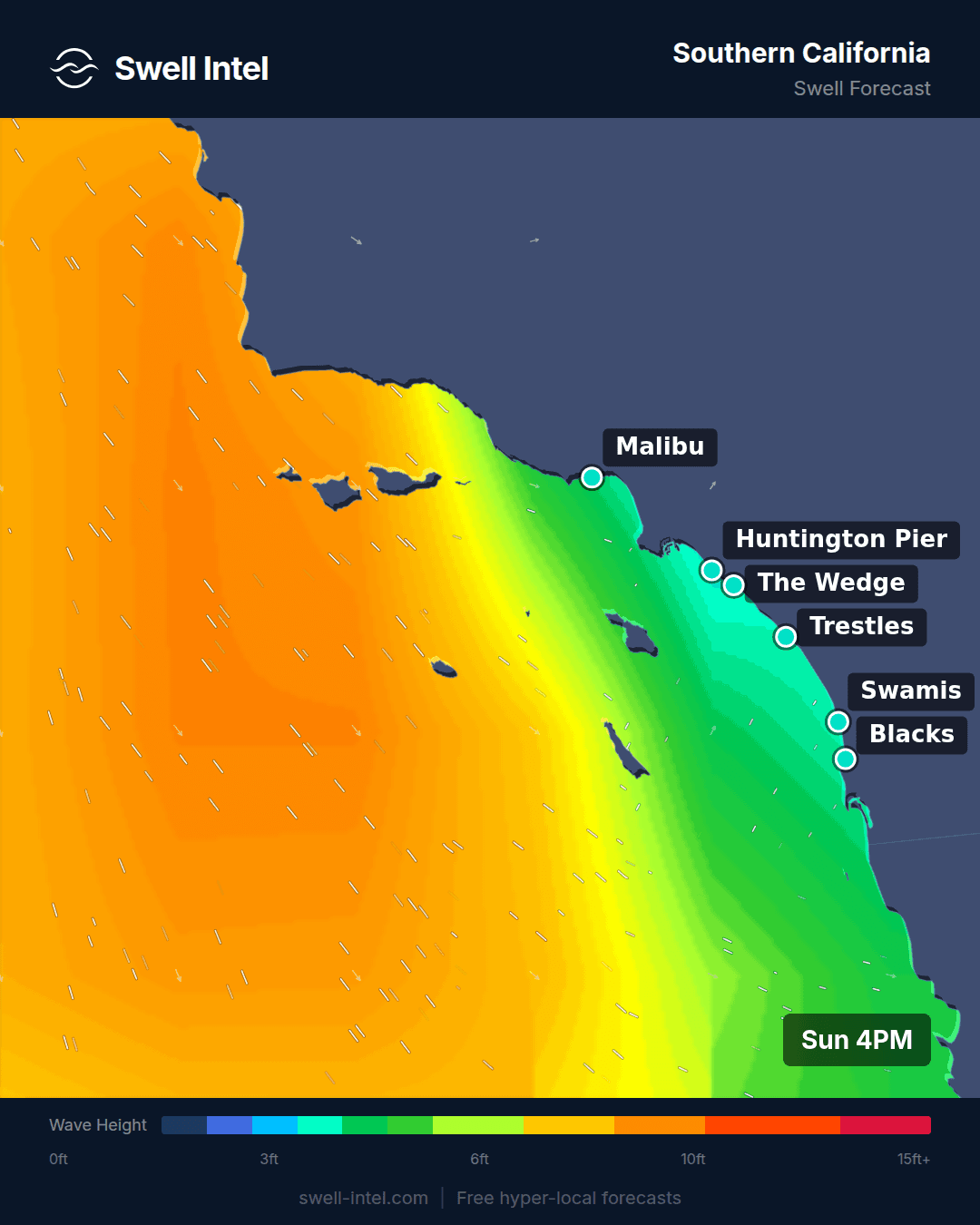
The period is the whole story here. Our model has the primary band arriving from 252-274° — west to west-southwest — at 5.7 to 6.1 seconds. Six seconds is windswell, not groundswell. The Southern Hemisphere season that fed Malibu, Trestles and Cardiff all summer has gone quiet, and nothing in this week's window replaces it, so what's left is a soft west fetch with no real push behind it. Southern California is the best-rated region on our board this week, and it is still only 2-3ft.
Trestles is the standout: the run peaks it at up to 5ft on the better sets with a Good rating, and Cardiff Reef is right behind at up to 4ft, also Good. I'd treat that 5ft as the ceiling of the range rather than the number to plan your morning around — at six seconds those sets stand up and go soft quickly, and the regional call of 2-3ft is the honest middle. Huntington Pier and Malibu First Point both run up to 3ft and rate Fair. El Porto is the one to skip, topping out around 2ft and rating Poor-Fair; a 264° swell at this period simply doesn't light it up.
Timing is unusually clear-cut. Our morning window scores 2.0 against 1.0 at midday and 0.7 in the afternoon — the steepest AM bias of any region this week. That is the textbook sea-breeze pattern: glassy and organised early, then the onshore fills in around late morning and grinds it down through the afternoon. Surf it before 10am or don't bother. The model puts the peak on Saturday the 19th, though see the confidence note below before you build a weekend around it.
Northern California

Surf: 1-2ft • Best day: Thursday AM • Conditions: Poor-Fair
This is the skip of the week, and there's no polite way around it. The primary band is 4.2 to 4.7 seconds from 291-300°. At those numbers you are not looking at swell, you are looking at chop that happens to be moving in one direction. Ocean Beach nominally reaches up to 4ft but rates Poor-Fair, and Linda Mar tops out near 2ft and rates Poor.
What makes it worse is the wind curve. Our afternoon rating for the region runs to -1.0, with midday at -0.1 and mornings only scraping 0.5. Negative is negative: the northwest sea breeze is actively wrecking whatever the morning leaves behind, which is the pattern Northern California lives with until the fall storm track properly takes over.
There is a detail worth noticing, because it's the kind of thing a single buoy reading hides. The Pacific Northwest is picking up 9-second energy from almost exactly the same direction band this week, and San Francisco is seeing 4-second slop. Same compass heading, completely different water. The generating fetch is sitting far enough north that Oregon and Washington are inside the swell window while Northern California is on its edge, catching a decayed remnant that local windsea then outranks. If you have a Thursday morning free, that's your only look — and it is a marginal one.
Pacific Northwest

Surf: 2-3ft • Best day: Friday AM • Conditions: Fair
This is the most legitimate swell on the West Coast this week. Our model has 8.8 to 9.1 seconds from 294-299° hitting the whole stretch from La Push down to Cape Kiwanda — genuine North Pacific groundswell rather than local wind chop, and the first clear signature of the fall pattern switching on. It isn't big, at a regional 2-3ft, but it has actual period behind it, which means it will break with shape instead of just standing up and crumbling.
Indian Beach is the pick, reaching up to 5ft with a Fair rating, and Cape Kiwanda is the other one worth the drive at up to 3ft, also Fair. Seaside Cove and La Push both reach around 3ft but rate Poor-Fair — enough to surf, not enough to plan a day around.
The interesting part is the timing, or rather the absence of it. Our day windows come out at 1.2 in the morning, 1.1 at midday and 1.2 in the afternoon — essentially flat. For the Pacific Northwest, where wind is normally the entire forecast and a good swell can be unsurfable by 9am, a week with no meaningful wind penalty is rare. Take the window that suits you rather than setting an alarm. Friday the 18th is the model's peak.
New York / New Jersey

Surf: 1-2ft • Best day: Monday PM • Conditions: Fair-Good
Manasquan is carrying this whole region. Our model reaches it to 4ft with a Fair-Good rating, the only break north of Cape Hatteras that scores above Fair all week. Rockaway and Pacific Blvd both cap out near 2ft and rate Poor-Fair. That's the honest split: one spot worth a session, two that are small.
The energy is arriving from 146-160° — southeast to south-southeast — at 4.7 to 5 seconds. It is worth saying plainly what that is, because mid-September is the climatological peak of the Atlantic hurricane season and this is not tropical groundswell. Five seconds from the southeast is local windswell generated close to home. The long-period energy that is in the Atlantic this week is aimed at the Southeast coast, not the Mid-Atlantic, which is why Hatteras is reading 9.3 seconds and Rockaway is reading under 5.
Timing runs backwards from the West Coast pattern: our ratings climb from 0.1 in the morning to 0.4 at midday and 1.0 in the afternoon, so this one builds as the day goes rather than fading. Monday afternoon, the 14th, is the call, and being early in the window it's one of the more reliable calls on this page.
New England

Surf: 1-2ft • Best day: Thursday AM • Conditions: Poor-Fair
Flattest region on the board. Every one of the four breaks we model here — Narragansett, Misquamicut, Hampton and Nantasket — tops out at 2ft and rates Poor-Fair. Not one of them separates from the others, which in forecasting terms usually means there is no real swell to distinguish them with.
Periods confirm it: 3.1 to 4.0 seconds. That is wind chop with a direction attached. What little there is comes from 134-165°, so the Rhode Island beaches get the better end of it — Narragansett at 165° and Misquamicut at 159° face south-southeast and take that angle more or less square on. Hampton in New Hampshire and Nantasket in Massachusetts face closer to east-northeast, so a south-southeast swell arrives at a glancing angle and loses most of what it had. Nantasket, reading 3.1 seconds, is the weakest signal anywhere on our East Coast board this week.
Our midday and afternoon ratings both go negative. Thursday morning, the 17th, is the only window that isn't actively bad, and even then this is a longboard session or a walk on the beach. If you were deciding between driving to Rhode Island and staying home, stay home.
Outer Banks & the Carolinas

Surf: 1-2ft • Best day: Sunday Midday • Conditions: Fair
Best day here is today, so this is the one region where reading this later costs you. Cape Hatteras is showing 9.3 seconds from 131°, the longest period of any spot in this week's entire run, coast to coast. It reaches up to 4ft with a Fair rating.
That period is worth explaining, because it tells you where the week's only real Atlantic energy is coming from. Long-period southeast swell showing at Hatteras and on the Florida coast, while New Jersey and New England see 3-5 seconds, means a distant source well out in the subtropical Atlantic with a swell window aimed squarely at the Southeast. The Mid-Atlantic and Northeast are outside that window. Hatteras earns its reputation as the East Coast's swell magnet precisely on weeks like this — it juts far enough into the Atlantic to intercept energy the rest of the seaboard never sees. Folly Beach Pier down in South Carolina reaches 3ft and rates Fair, but it's riding a different, shorter 4.5-second band from 165° rather than the same groundswell.
Wind shapes the day strangely here. Our ratings run -0.8 in the morning and -0.7 in the afternoon, with midday at 0.0 — both ends of the day are compromised and the middle is merely neutral. Go at lunch. And go today: the model has it easing off from Monday.
Florida East Coast

Surf: 1-2ft • Best day: Monday AM • Conditions: Fair-Good
Florida gets the best angle on that same distant Atlantic source, and it produces the best-rated morning on the East Coast this week. Cocoa Beach reaches up to 4ft at Fair-Good, Sebastian Inlet matches it at up to 4ft with a Fair rating, and Jacksonville Beach trails at up to 3ft, Poor-Fair.
The numbers behind it are 8.0 to 8.5 seconds from 84-107°, which is very close to due east. That matters more in Florida than almost anywhere else on our board: the Bahamas sit directly offshore and block most of the angles, so east coast breaks depend on energy threading the gaps in that bank. A due-east approach at 8.5 seconds is about as favourable as that geometry gets short of a direct tropical hit. It is still a 1-2ft regional call — nobody should read "best on the East Coast" as "big" — but for Florida in September it's a genuinely worthwhile morning.
Morning is the operative word. Our ratings drop from 0.6 at dawn to -0.2 at midday and -0.6 by afternoon, the sharpest decay of any region this week, and that is the Florida sea breeze doing exactly what it does every day of the warm season. Monday the 14th at first light, or you've missed it.
Puerto Rico

Surf: 1-2ft • Best day: Friday AM • Conditions: Fair
Small, and seasonally right on schedule. Our model has 4.7 seconds from 58-67° — east-northeast, which is the trade wind band. That is what Puerto Rico looks like in September. The north and northwest groundswell season that makes the island worth a plane ticket doesn't switch on until October, and nothing in this week's window arrives early.
Wilderness, out on the northwest coast near Aguadilla, reaches up to 3ft and rates Fair. Maria's, around in Rincon, reaches 2ft and rates Poor, and it's worth being direct about why: Maria's faces west-northwest and needs north or northwest energy to produce the long walls it's known for. Trade swell from the east-northeast gives it almost nothing. The usual rule holds even at this size — the north coast runs bigger, Rincon is the quality play when there's real swell, and this week there isn't real swell.
Mornings are the play at 1.0 against 0.5 later in the day, which is the trades filling in and roughing up the surface as the day heats up. Friday the 18th rates best, at the low-confidence end of the window.
Confidence on these calls
We state this explicitly rather than letting vague language do the work. Confidence is high on the first three days — the Sunday call for Cape Hatteras, the Monday calls for Florida and New Jersey, and the general read that this is a small week for everyone. It drops through the back half. The Thursday windows for Northern California and New England, and the Friday and Saturday peaks for the Pacific Northwest, Puerto Rico and Southern California, sit at the far end of a seven-day window where period and timing routinely shift by half a day or more. Treat those as the shape of the week, not appointments. Check back midweek and we'll have run the grids again.
One more calibration note, since it applies to several regions above: where a single spot's peak runs well clear of the regional call — Trestles at up to 5ft against a 2-3ft Southern California read, Indian Beach at up to 5ft against 2-3ft in the Pacific Northwest — the peak is the top of the modelled range on the better sets, not the number to plan around. We would rather you turn up to slightly better surf than we promised.
Track it live in Swell Intel
These maps are a snapshot of a model that updates continuously. For live nearshore forecasts at every break named above — hourly breaking wave height, period, direction and wind, at the spot rather than at the buoy — open Swell Intel and check your break before you load the car.
📱 Get spot-by-spot forecasts, dawn patrol alerts, and buoy-trained ratings in the SwellIntel app.